
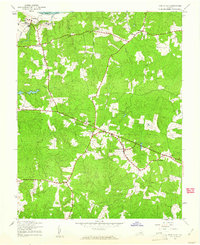
1943 Map of Powhatan
USGS Topo · Published 1943About this map
The James River forms the northern boundary of this Piedmont landscape, where the confluence of several large creeks shaped early Virginia transit and settlement patterns. During the early 1940s, the area around the county seat of Powhatan remained primarily agricultural, supported by centers like Goodwins Store and a local Sawmill. The map reveals a segregated educational landscape, specifically noting the Powhatan County High School (Colored) alongside several Catholic institutions such as the St Emma School and St Francis de Sales School near the river. Significant local identifiers include the community of Mohemenco (Provost P O) and the village of Macon. Numerous rural houses of worship, including Fine Creek Church and Emmanuel Church, are distributed along the ridge roads between drainages like Fine Creek and Fighting Creek.
Find a feature on this map
25 named features on this map. Tap any name to fly to it.
Don’t see what you’re looking for? This feature index may not catch every label — zoom into the map to look around manually.
Map Details
Editions of this 1943 Powhatan Map
2 editions found
Other maps of this area

1890 · Goochland
USGS Topo · 1:125,000

1891 · Palmyra
USGS Topo · 1:125,000

1891 · Farmville
USGS Topo · 1:125,000

1892 · Goochland
USGS Topo · 1:125,000

1893 · Farmville
USGS Topo · 1:125,000

1895 · Palmyra
USGS Topo · 1:125,000

1897 · Amelia
USGS Topo · 1:125,000

1897 · Palmyra
USGS Topo · 1:125,000

1943 · Goochland
USGS Topo · 1:31,680

1943 · Fine Creek Mills
USGS Topo · 1:31,680