
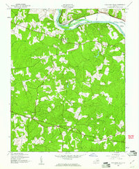
1943 Map of Fine Creek Mills
USGS Topo · Published 1943About this map
Fine Creek Mills and the surrounding Virginia countryside appear in this 1943 survey, showing a landscape defined by agricultural estates and small community centers. The northern edge follows the winding James River, where the Chesapeake and Ohio railroad runs parallel to the bank, passing the prominent State Farm and Sabot Hill Farm. This riverine boundary separates Goochland and Powhatan counties, with Sabot Island sitting in the channel near the mouth of the Little River.
Find a feature on this map
30 named features on this map. Tap any name to fly to it.
Don’t see what you’re looking for? This feature index may not catch every label — zoom into the map to look around manually.
Map Details
Editions of this 1943 Fine Creek Mills Map
2 editions found
Other maps of this area

1890 · Goochland
USGS Topo · 1:125,000

1892 · Goochland
USGS Topo · 1:125,000

1897 · Amelia
USGS Topo · 1:125,000

1943 · Goochland
USGS Topo · 1:31,680

1943 · Powhatan
USGS Topo · 1:31,680

1943 · Perkinsville
USGS Topo · 1:31,680

1943 · Hallsboro
USGS Topo · 1:31,680

1943 · Clayville
USGS Topo · 1:24,000

1943 · Midlothian
USGS Topo · 1:24,000
1943 · Johnsons Springs
USGS Topo · 1:24,000