1943 Map of Powhatan
USGS Topo · Published 1961About this map
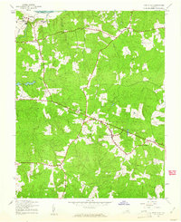
Powhatan serves as the central hub for this rural landscape during the early 1940s, situated at a major crossroads south of the James River. The terrain is defined by a dense network of drainage, where creeks like Fine Creek, Fighting Creek, and Sallie Creek carve through the wooded uplands. This era shows a community rooted in local institutions, evidenced by the presence of numerous small country churches including New Greenbriar Ch, Emmanuel Ch, and Union Branch Ch. Educational sites are particularly prominent, featuring both the Powhatan County High Sch and religious-affiliated institutions such as St Emma Sch and St Francis de Sales Sch near the northern border with Goochland County. The distribution of small settlements like Jefferson, Mohemenco, and Macon illustrates the mid-century agricultural and residential patterns of the Virginia Piedmont before late-20th-century suburbanization.
Find a feature on this map
29 named features on this map. Tap any name to fly to it.
Don’t see what you’re looking for? This feature index may not catch every label — zoom into the map to look around manually.
Map Details
Editions of this 1943 Powhatan Map
2 editions found

Other maps of this area

1890 · Goochland
USGS Topo · 1:125,000

1891 · Palmyra
USGS Topo · 1:125,000

1891 · Farmville
USGS Topo · 1:125,000

1892 · Goochland
USGS Topo · 1:125,000

1893 · Farmville
USGS Topo · 1:125,000

1895 · Palmyra
USGS Topo · 1:125,000

1897 · Amelia
USGS Topo · 1:125,000

1897 · Palmyra
USGS Topo · 1:125,000

1943 · Goochland
USGS Topo · 1:31,680

1943 · Fine Creek Mills
USGS Topo · 1:31,680