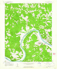
1943 Map of Goochland
USGS Topo · Published 1961About this map
The James River carves a sweeping path through this Virginia countryside, acting as the primary geographical anchor for the surrounding rural communities. During the early 1940s, the Chesapeake and Ohio railroad followed the river's northern bank, connecting the county seat at Goochland with smaller stations and stops like Irwin and Maidens. This era shows a landscape deeply integrated with state-run institutions and community-centered infrastructure, notably the State Farm and Beaumont State Sch located near the river's bend.
Find a feature on this map
32 named features on this map. Tap any name to fly to it.
Don’t see what you’re looking for? This feature index may not catch every label — zoom into the map to look around manually.
Map Details
Editions of this 1943 Goochland Map
2 editions found
Other maps of this area

1890 · Goochland
USGS Topo · 1:125,000

1891 · Palmyra
USGS Topo · 1:125,000

1892 · Goochland
USGS Topo · 1:125,000

1895 · Palmyra
USGS Topo · 1:125,000

1897 · Palmyra
USGS Topo · 1:125,000

1943 · Goochland
USGS Topo · 1:31,680

1943 · Fine Creek Mills
USGS Topo · 1:31,680

1943 · Powhatan
USGS Topo · 1:31,680

1943 · Perkinsville
USGS Topo · 1:31,680

1943 · South Anna
USGS Topo · 1:24,000