1990s Maps of Greene County, Virginia
Explore 4 historic maps of Greene County from the 1990s. These maps offer a rare glimpse into what life looked like during the 1990s — showing old roads, neighborhoods, homes, and landmarks that have changed or disappeared over time.
Whether you're researching your family's past, planning a metal detecting trip, or studying how Greene County's landscape evolved across the 1990s, these high-resolution maps are a powerful tool for exploring the history of this region.
- Focus on a specific era: All maps on this page are from the 1990s, giving you a focused view of this time period.
- See what’s changed: Compare century-old streets, trails, and buildings to today's modern landscape using overlays and satellite layers.
- Research with precision: Use these maps for genealogy, historical research, land use analysis, or educational projects.
- View, download, or print: Maps are fully viewable online in high resolution, and can be downloaded or printed for your own records.
Start exploring Greene County's history through authentic maps from the 1990s. This is your window into the past.
Greene County, VA maps
(4)- 1997 Map of Elkton East, 1999 Print
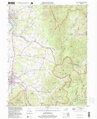 1997 Elkton East1999 Print · USGSThe Shenandoah Valley meets the Blue Ridge in the late twentieth century, showing a mix of mountain wilderness and river-town life. Trace family sites at Naylor Cem, old routes near Furnace, and springs like Bear Lithia Spring.
 - 1997 Map of Swift Run Gap, 1999 Print
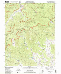 1997 Swift Run Gap1999 Print · USGSGreene County’s Blue Ridge foothills are captured here in the late 1990s, where traditional hollow settlements meet the wilderness of the national park. Researchers can locate family landmarks like the Mission Home Cem and several rural sanctuaries including Gibson Chapel and Evergreen Ch.
 - 1999 Map of Fletcher, 2000 Print
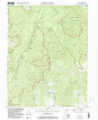 1999 Fletcher2000 Print · USGSThe Blue Ridge highlands meet the rural settlements of Madison County in the late 1990s as the wilderness of Shenandoah transitions to mountain valleys. Genealogists and hikers can trace the Appalachian Trail past historic sites like Fletcher, Shiloh Ch, and the Lower Pocosin Mission.
 - 1999 Map of Mc Gaheysville, 2001 Print
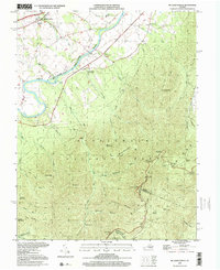 1999 Mc Gaheysville2001 Print · USGSRockingham County at the close of the twentieth century shows a valley shaped by the river and the Blue Ridge mountains. Genealogists and hikers can trace old valley settlements like McGaheysville or explore high-country landmarks like the Appalachian Trail and Mt Olivet Cem.
End of results
Showing maps 1-4 of 4
Top cities of Greene County
Frequently asked questions
- What are the different types of historical maps available for Greene County?
- What is the oldest map of Greene County?
- Where can I purchase historical maps of Greene County for my home or office?
- Where can I download high-res historical maps of Greene County?
- Are there historical topographic maps available for Greene County?
- Is there historical aerial imagery available for Greene County?
- Where are historical maps of Greene County sourced from?