1970s Maps of Greene County, Virginia
Explore 9 historic maps of Greene County from the 1970s. These maps offer a rare glimpse into what life looked like during the 1970s — showing old roads, neighborhoods, homes, and landmarks that have changed or disappeared over time.
Whether you're researching your family's past, planning a metal detecting trip, or studying how Greene County's landscape evolved across the 1970s, these high-resolution maps are a powerful tool for exploring the history of this region.
- Focus on a specific era: All maps on this page are from the 1970s, giving you a focused view of this time period.
- See what’s changed: Compare century-old streets, trails, and buildings to today's modern landscape using overlays and satellite layers.
- Research with precision: Use these maps for genealogy, historical research, land use analysis, or educational projects.
- View, download, or print: Maps are fully viewable online in high resolution, and can be downloaded or printed for your own records.
Start exploring Greene County's history through authentic maps from the 1970s. This is your window into the past.
Greene County, VA maps
(9)- 1977 Map of Stanardsville, 1981 Print
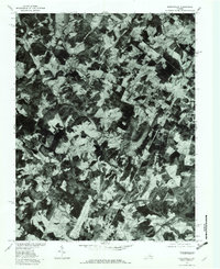
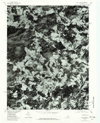
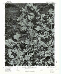 1977 Stanardsville1981 Print · USGSStanardsville and the surrounding Greene County countryside are captured in this late-seventies aerial survey. Genealogists and local historians can trace farmstead boundaries and rural clusters near Mc Mullen, Lydia, and the banks of the South River.
 - 1977 Map of Fletcher, 1981 Print
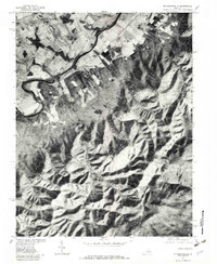
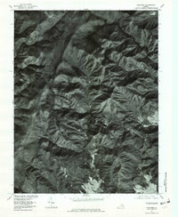 1977 Fletcher1981 Print · USGSThe high mountain country near the Madison and Greene county line comes into focus in the late 1970s. Trace the remote settlement at Fletcher, the heights of Bearfence Mountain, and the winding route of Skyline Drive.
 - 1977 Map of Rochelle, 1981 Print
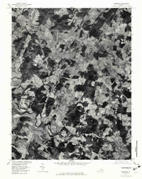 1977 Rochelle1981 Print · USGSMadison County's Piedmont landscape is documented in the late seventies through detailed aerial imagery. Genealogists and local historians can trace the rural layout of communities like Rochelle, Wolftown, and Dawsonville along the Rapidan River.
 - 1977 Map of Elkton East, 1981 Print
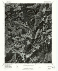 1977 Elkton East1981 Print · USGSThe Rockingham County valley meets the Blue Ridge in the late seventies. Family historians can trace rural settlements like Furnace and Verbena, or locate land along Naked Creek and Elk Run.
 - 1977 Map of Earlysville, 1982 Print
 1977 Earlysville1982 Print · USGSThe rural landscapes of Albemarle County are captured during the late 1970s, showing the agricultural heart of the Virginia Piedmont. Researchers can trace historic property boundaries and river crossings near Earlysville, Advance Mills, and the slopes of Piney Mountain.
 - 1977 Map of Barboursville, 1982 Print
 1977 Barboursville1982 Print · USGSThe Virginia Piedmont's agricultural landscape is seen in detail during the late seventies, showing the rural communities of Orange and Greene counties. Trace historic family lands and farmstead locations near Barboursville, Eheart, and the winding Preddy Creek.
 - 1977 Map of Mc Gaheysville, 1982 Print
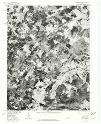
 1977 Mc Gaheysville1982 Print · USGSRockingham County in the late seventies is shown in remarkable detail through this aerial orthophotoquad. Genealogists and local historians can trace the property lines near Mc Gaheysville, Berrytown, and the South Fork Shenandoah River.
 - 1977 Map of Swift Run Gap, 1982 Print
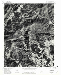 1977 Swift Run Gap1982 Print · USGSGreene County’s mountain passes and valley settlements are captured in the late seventies just as the landscape balanced traditional farming and parkland. Researchers can trace rural road networks and family-named landmarks like Bacon Hollow, Haneytown, and Dyke.
 - 1977 Map of Free Union, 1982 Print
 1977 Free Union1982 Print · USGSAlbemarle County's rolling Piedmont and rising foothills are seen in the late seventies as a landscape of rural farmsteads and ancient watercourses. Genealogists can locate family lands near Free Union, Boonesville, and the banks of the Lynch River.
End of results
Showing maps 1-9 of 9
Top cities of Greene County
Frequently asked questions
- What are the different types of historical maps available for Greene County?
- What is the oldest map of Greene County?
- Where can I purchase historical maps of Greene County for my home or office?
- Where can I download high-res historical maps of Greene County?
- Are there historical topographic maps available for Greene County?
- Is there historical aerial imagery available for Greene County?
- Where are historical maps of Greene County sourced from?