1930s Maps of Barkers Mill, Virginia
Explore 2 historic maps of Barkers Mill from the 1930s. These maps offer a rare glimpse into what life looked like during the 1930s — showing old roads, neighborhoods, homes, and landmarks that have changed or disappeared over time.
Whether you're researching your family's past, planning a metal detecting trip, or studying how Barkers Mill's landscape evolved across the 1930s, these high-resolution maps are a powerful tool for exploring the history of this region.
- Focus on a specific era: All maps on this page are from the 1930s, giving you a focused view of this time period.
- See what’s changed: Compare century-old streets, trails, and buildings to today's modern landscape using overlays and satellite layers.
- Research with precision: Use these maps for genealogy, historical research, land use analysis, or educational projects.
- View, download, or print: Maps are fully viewable online in high resolution, and can be downloaded or printed for your own records.
Start exploring Barkers Mill's history through authentic maps from the 1930s. This is your window into the past.
Barkers Mill, VA maps
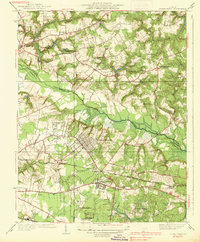
(2)- 1934 Map of Seven Pines
 1934 Seven Pines1934 Print · USGSHenrico and Hanover counties are seen here in the mid-1930s, documenting a landscape where historic battlegrounds met the dawn of modern aviation. Researchers can trace the legacy of local conflict through the National Cem or locate community centers like New Bridge Ch and Highland Springs.
 - 1938 Map of Seven Pines
 1938 Seven Pines1938 Print · USGSEastern Henrico County and Hanover County are seen here in the mid-1930s as suburban growth began to meet rural history. Genealogists and historians can trace family landmarks like the Trent House, find rural schools such as Dry Bridge Sch, and locate the early Richard E Byrd Landing Field.3 unique versions available
End of results
Showing maps 1-2 of 2
Top cities near Barkers Mill
- Richmond historical maps
- Mechanicsville historical maps
- Chester historical maps
- Meadowbrook historical maps
- Highland Springs historical maps
- Lakeside historical maps
See more
Frequently asked questions
- What are the different types of historical maps available for Barkers Mill?
- What is the oldest map of Barkers Mill?
- Where can I purchase historical maps of Barkers Mill for my home or office?
- Where can I download high-res historical maps of Barkers Mill?
- Are there historical topographic maps available for Barkers Mill?
- Is there historical aerial imagery available for Barkers Mill?
- Where are historical maps of Barkers Mill sourced from?