1940s Maps of Rolfield, Henrico County
Explore 5 historic maps of Rolfield from the 1940s. These maps offer a rare glimpse into what life looked like during the 1940s — showing old roads, neighborhoods, homes, and landmarks that have changed or disappeared over time.
Whether you're researching your family's past, planning a metal detecting trip, or studying how Rolfield's landscape evolved across the 1940s, these high-resolution maps are a powerful tool for exploring the history of this region.
- Focus on a specific era: All maps on this page are from the 1940s, giving you a focused view of this time period.
- See what’s changed: Compare century-old streets, trails, and buildings to today's modern landscape using overlays and satellite layers.
- Research with precision: Use these maps for genealogy, historical research, land use analysis, or educational projects.
- View, download, or print: Maps are fully viewable online in high resolution, and can be downloaded or printed for your own records.
Start exploring Rolfield's history through authentic maps from the 1940s. This is your window into the past.
Rolfield, Henrico County maps
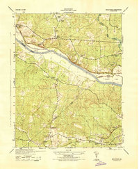
(5)- 1942 Map of Westhampton
 1942 Westhampton1942 Print · USGSThe James River corridor west of Richmond was a mix of historic estates and rural crossroads in the early 1940s. Genealogists can locate family landmarks like Hammack Mill, trace the Kanawha Canal, or find old sites like the Bellona Arsenal (Ruins).2 unique versions available
 - 1943 Map of Midlothian, 1961 Print
 1943 Midlothian1961 Print · USGSMidlothian and the James River valley are shown here during the early 1940s, when river islands and rail lines defined the local geography. Genealogists and local historians can trace the foundations of Midlothian, locate the Granite Quarries, and identify rural landmarks like Winfree Ch and Manakin Sch.
 - 1943 Map of Richmond, 1972 Print
 1943 Richmond1972 Print · USGSCoastal Virginia and the state capital are shown in detail during the mid-century era of infrastructure expansion. Genealogists and historians can trace the grounds of Richmond Nat Battlefield Park, locate the Yorktown Nat Cem, or follow the many rural routes through Amelia Court House and Tappahannock.
 - 1944 Map of Midlothian
 1944 Midlothian1944 Print · USGSMid-1940s Virginia reveals a river-driven landscape where the James River and the Chesapeake and Ohio railroad define regional growth. Genealogists can trace family landmarks like Tuckahoe Estate, Watkins Nurseries, and the Huguenot Monument.
 - 1949 Map of Richmond, 1951 Print
 1949 Richmond1951 Print · USGSCoastal Virginia in the years following World War II remained a landscape of historic river towns and expanding military bases. Genealogists and historians can trace the rail lines of the Southern Ry and locate established landmarks from Camp Lee to the remote reaches of Dragon Swamp.
End of results
Showing maps 1-5 of 5
Frequently asked questions
- What are the different types of historical maps available for Rolfield?
- What is the oldest map of Rolfield?
- Where can I purchase historical maps of Rolfield for my home or office?
- Where can I download high-res historical maps of Rolfield?
- Are there historical topographic maps available for Rolfield?
- Is there historical aerial imagery available for Rolfield?
- Where are historical maps of Rolfield sourced from?