1960s Maps of Windsor, Virginia
Explore 2 historic maps of Windsor from the 1960s. These maps offer a rare glimpse into what life looked like during the 1960s — showing old roads, neighborhoods, homes, and landmarks that have changed or disappeared over time.
Whether you're researching your family's past, planning a metal detecting trip, or studying how Windsor's landscape evolved across the 1960s, these high-resolution maps are a powerful tool for exploring the history of this region.
- Focus on a specific era: All maps on this page are from the 1960s, giving you a focused view of this time period.
- See what’s changed: Compare century-old streets, trails, and buildings to today's modern landscape using overlays and satellite layers.
- Research with precision: Use these maps for genealogy, historical research, land use analysis, or educational projects.
- View, download, or print: Maps are fully viewable online in high resolution, and can be downloaded or printed for your own records.
Start exploring Windsor's history through authentic maps from the 1960s. This is your window into the past.
Windsor, VA maps
(2)- 1965 Map of Windsor, 1966 Print
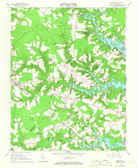 1965 Windsor1966 Print · USGSWindsor and the surrounding Isle of Wight County countryside are shown here in the mid-1960s, a landscape defined by expansive reservoirs and the Norfolk and Western railway. Researchers can locate family landmarks like Holly Grove Ch, the old Garner Airport, and the small settlement of Indika.5 unique versions available
 - 1969 Map of Zuni, 1971 Print
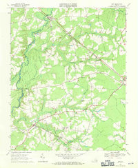 1969 Zuni1971 Print · USGSCoastal plain Virginia life in the late sixties is centered on the rail-and-river network of the Blackwater River. Genealogists and historians can trace family locations near Collosse, rural churches like Morning Star Ch, and the State Prison Camp No 3.3 unique versions available
End of results
Showing maps 1-2 of 2
Top cities near Windsor
- Suffolk historical maps
- Franklin historical maps
- Smithfield historical maps
- Carrollton historical maps
- Benns Church historical maps
- Camptown historical maps
See more
Frequently asked questions
- What are the different types of historical maps available for Windsor?
- What is the oldest map of Windsor?
- Where can I purchase historical maps of Windsor for my home or office?
- Where can I download high-res historical maps of Windsor?
- Are there historical topographic maps available for Windsor?
- Is there historical aerial imagery available for Windsor?
- Where are historical maps of Windsor sourced from?