1950s Maps of King George County, Virginia
Explore 8 historic maps of King George County from the 1950s. These maps offer a rare glimpse into what life looked like during the 1950s — showing old roads, neighborhoods, homes, and landmarks that have changed or disappeared over time.
Whether you're researching your family's past, planning a metal detecting trip, or studying how King George County's landscape evolved across the 1950s, these high-resolution maps are a powerful tool for exploring the history of this region.
- Focus on a specific era: All maps on this page are from the 1950s, giving you a focused view of this time period.
- See what’s changed: Compare century-old streets, trails, and buildings to today's modern landscape using overlays and satellite layers.
- Research with precision: Use these maps for genealogy, historical research, land use analysis, or educational projects.
- View, download, or print: Maps are fully viewable online in high resolution, and can be downloaded or printed for your own records.
Start exploring King George County's history through authentic maps from the 1950s. This is your window into the past.
King George County, VA maps
(8)- 1952 Map of Rappahannock Academy
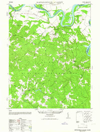 1952 Rappahannock Academy1952 Print · USGSCaroline County undergoes a major transition in the early 1950s as military boundaries expand across traditional farmlands. You can trace old family sites and rural infrastructure like Moss Neck Manor, Travis Mill, and Rappahannock Academy.
 - 1952 Map of Port Royal
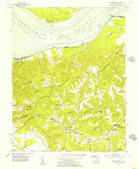
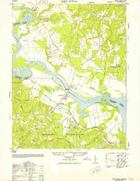 1952 Port Royal1952 Print · USGSThe Rappahannock River separates historic river towns and expanding military grounds in the early 1950s. Genealogists can trace family landmarks and rural life through Port Royal, the Welcome School, and Immanuel Church.
 - 1952 Map of Passapatanzy
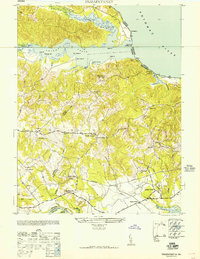 1952 Passapatanzy1952 Print · USGSStafford and King George counties at mid-century show a landscape of tidal creeks and quiet rural crossroads. Genealogists can trace family-named sites like Spillmans Ldg and Graves Corner or locate old post offices at Goby PO and Sealston PO.
 - 1953 Map of Morgantown, 1954 Print
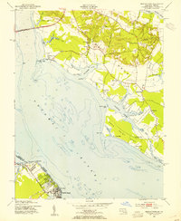 1953 Morgantown1954 Print · USGSMaryland's tidewater necks and the Virginia riverfront are captured here in the early fifties as the region's bridge-and-road network expanded. Researchers can trace historic church sites like Old Christ Church and early landings such as Wilkerson Wharf and Morgantown.3 unique versions available
 - 1954 Map of Mathias Point, 1955 Print
 1954 Mathias Point1955 Print · USGSMaryland's tidewater peninsulas and the Virginia shoreline appear here in the mid-fifties as a mix of military testing grounds and rural river life. Genealogists and local historians can trace family locations near St Ignatius Ch, the Blossom Point Proving Grounds, and the settlement at Welcome.2 unique versions available
 - 1955 Map of Dahlgren, 1956 Print
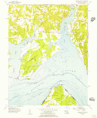
 1955 Dahlgren1956 Print · USGSThe Virginia shoreline of the Potomac is shown here during the mid-fifties, dominated by military development and rural river towns. Genealogists and local historians can trace family roots through sites like Little Ark Ch, Spy Hill Cem, and the village of Tetotum.
 - 1955 Map of King George, 1956 Print
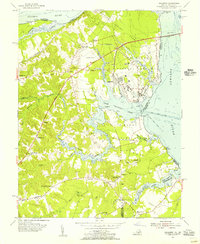
 1955 King George1956 Print · USGSKing George and the Northern Neck peninsula are captured here in the mid-fifties, showing the rural community and riverfront as they existed before modern expansion. Genealogists and historians can locate numerous family burial sites and country churches, including Sorrels Cem, Grymes Cem, and Pilgrim Holy Ch.
 - 1957 Map of Washington, 1966 Print
 1957 Washington1966 Print · USGSThe mid-Atlantic region during the mid-fifties and early sixties reveals a landscape of growing suburbs and vital military outposts. Researchers can trace historic river towns and shorelines from Alexandria to the Hooper Islands and St Clements Island.5 unique versions available
End of results
Showing maps 1-8 of 8
Top cities of King George County
- King George historical maps
- Dahlgren historical maps
- Passapatanzy historical maps
- Dahlgren Center historical maps
- Fairview Beach historical maps
Frequently asked questions
- What are the different types of historical maps available for King George County?
- What is the oldest map of King George County?
- Where can I purchase historical maps of King George County for my home or office?
- Where can I download high-res historical maps of King George County?
- Are there historical topographic maps available for King George County?
- Is there historical aerial imagery available for King George County?
- Where are historical maps of King George County sourced from?