Old Maps of King George County, Virginia for Academic Research
Study the evolution of King George County with 56 high-resolution historic maps. Whether you're teaching, researching, or modeling changes in land use, these maps provide essential visual documentation of urban, environmental, and geographic change.
- Analyze long-term change: Track patterns in development, transportation, and natural features.
- Ideal for environmental or urban studies: Support academic projects with primary historical map data.
- Use in the classroom or lab: Educators and researchers rely on these maps to bring historical context to life.
These maps are a powerful tool for teaching, research, and visualizing how King George County has changed over the decades.
King George County, VA maps
(56)- 1889 Map of Fredericksburg
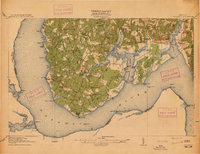
 1889 Fredericksburg1889 Print · USGSThe Tidewater region of Virginia and Maryland comes into focus in the late 1880s, centered on the river-and-rail hub of Fredericksburg. Genealogists can trace early landmarks like Rappahannock Academy, Bull Church, and Saunders Wharf.
 - 1892 Map of Fredericksburg
 1892 Fredericksburg1892 Print · USGSCoastal Virginia and Maryland are captured here in the late nineteenth century, showing a landscape of river-port towns and historic crossroads. Researchers can locate vanished landmarks and family sites like Rappahannock Academy, Whites Mill, and the riverside Port Royal.
 - 1894 Map of Wicomico
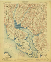
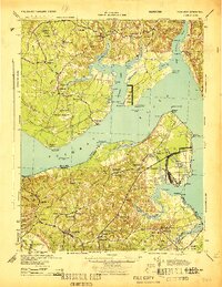
 1894 Wicomico1894 Print · USGSThe Southern Maryland tidewater and Virginia's Northern Neck are captured here in the 1890s, when river wharves and early railroads still dictated local life. Trace the old ferry crossings at Ludlow Ferry and historic landing sites like Plowdens Wharf and Wilkerson Wharf.
 - 1894 Map of Fredericksburg
 1894 Fredericksburg1894 Print · USGSThe Tidewater and Piedmont regions of Virginia meet in the late nineteenth century at the head of the Rappahannock River. Local historians can trace early inland commerce through rural centers like Nindes Store, the Rappahannock Academy, and Stafford.10 unique versions available
 - 1895 Map of Wicomico
 1895 Wicomico1895 Print · USGSSouthern Maryland and the Virginia shore come alive in this late nineteenth-century survey of the Potomac and Wicomico watersheds. Genealogists and historians can trace old river landings like Plowdens Wharf, early rail routes, and established communities from Charlotte Hall to Chaptico.
 - 1895 Map of Nomini
 1895 Nomini1895 Print · USGSSouthern Maryland and the Virginia tidewater shores meet along the Potomac in this late nineteenth-century survey. Genealogists can trace family holdings and river landings from Charlotte Hall down to Sotterly and the Nomini Ferry.
 - 1898 Map of Nomini
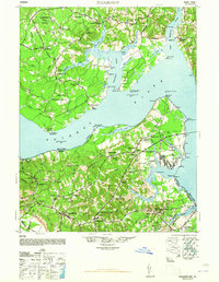
 1898 Nomini1898 Print · USGSMaryland and Virginia's Tidewater region comes alive in the late nineteenth century as a world of river landings, rail terminals, and rural crossroads. Researchers can trace the maritime economy through Nomini Ferry and Stone Wharf, or locate ancestral homesteads near Charlotte Hall and Potomac Mills.5 unique versions available
 - 1902 Map of Wicomico
 1902 Wicomico1902 Print · USGSCoastal Maryland at the turn of the century shows a landscape tied to the tides and the tracks. Trace the vital waterfront economy through Ludlow Ferry and Plowdens Wharf, or follow the path of the Southern Maryland R. R. past Charlotte Hall.5 unique versions available
 - 1911 Map of Wicomico, 1961 Print
 1911 Wicomico1961 Print · USGSSouthern Maryland's river-dependent landscape is documented here during the early twentieth century, showing the tidewater border of Charles and St Marys counties. Genealogists can trace family-named points and wharves like Lancaster Wharf, the Laidlow Ferry, and the rail terminus at Popes Creek.
 - 1913 Map of Nanjemoy
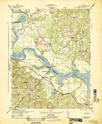
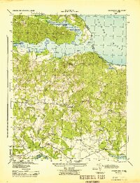
 1913 Nanjemoy1913 Print · USGSThe Nanjemoy peninsula in the early nineteen-hundreds was a world of tidal creeks and tobacco landings. Researchers can trace the rural fabric of Charles County through family-named landmarks like Mudds Marsh and community hubs such as Durham Church and Green Leek School.3 unique versions available
 - 1914 Map of Wicomico
 1914 Wicomico1914 Print · USGSSouthern Maryland's riverfront life is captured here during the early twentieth century, showing a landscape of tidal creeks and busy steamboat landings. Genealogists can trace family footprints near Charlotte Hall, find old crossings like Ludlow Ferry, or locate historic maritime hubs like Bushwood Wharf.4 unique versions available
 - 1920 Map of Wicomico
 1920 Wicomico1920 Print · USGSThe Potomac and Wicomico riverfronts appear here as they were just after the Great War, when steamboat wharves and ferries still anchored local commerce. Trace the old rail lines to Bel Alton Cox Sta or locate long-standing landmarks like Charlotte Hall and Ludlow Ferry.
 - 1926 Map of Stafford, 1956 Print
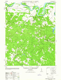
 1926 Stafford1956 Print · USGSStafford County and the Rappahannock River valley appear here in the mid-twenties, balancing colonial-era heritage with early twentieth-century growth. Genealogists can locate family landmarks like Bridges Store, Passapatanzy, and the historic Aquia Ch along the rail lines.
 - 1931 Map of Stafford
 1931 Stafford1931 Print · USGSStafford County and the city of Fredericksburg are shown here in the early 1930s, documenting a landscape still deeply shaped by nineteenth-century transit and conflict. Genealogists and historians can locate family landmarks like Mountain View PO, Enon Sch, and the grounds of the Battle of Fredericksburg 1862.
 - 1942 Map of Rollins Fork
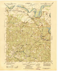
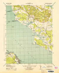
 1942 Rollins Fork1942 Print · USGSThe Northern Neck region during the early 1940s reveals a landscape defined by the river economy and established rural crossroads. Genealogists and local historians can trace family land and community hubs from Wilmont Wharf on the river to inland points like Rollins Fork and Kings Mill.
 - 1942 Map of Port Royal
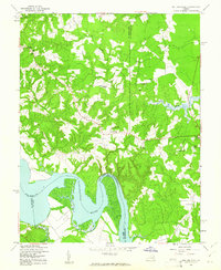
 1942 Port Royal1942 Print · USGSThe Rappahannock River valley was undergoing a major transition during the early 1940s as military footprints expanded. Genealogists and historians can trace the early borders of the A P Hill Military Reservation and find local hubs like Port Royal, Office Hall, and Port Conway.
 - 1942 Map of Rappahannock Academy, 1944 Print
 1942 Rappahannock Academy1944 Print · USGSThe Rappahannock River valley in the early 1940s reveals a rural landscape undergoing a massive military transformation. You can trace the early layout of the A P Hill Military Reservation and locate historic community centers like Rappahannock Academy and Travis Mill.
 - 1943 Map of Morgantown
 1943 Morgantown1943 Print · USGSThe Potomac and Wicomico riverfronts come alive in this wartime survey of the Maryland-Virginia borderlands. Genealogists and local historians can trace family-named landmarks like Harris Lot and Bachelors Hope Pt or locate old community centers such as Old Christ Ch and the Tompkinsville Sch.
 - 1944 Map of Passapatanzy
 1944 Passapatanzy1944 Print · USGSThe Virginia riverfront along the Potomac and Rappahannock appears here during the height of the Second World War. Genealogists and historians can trace family-named landmarks and rural hubs like Passapatanzy, Sealston PO, and the U. S. Government Railroad.
 - 1944 Map of Nanjemoy
 1944 Nanjemoy1944 Print · USGSMaryland and Virginia meet across the Potomac River during the 1940s, showing a region defined by naval operations and rural tidewater life. Researchers can trace military footprints at Dahlgren and Blossom Point Proving Ground or find old community centers like Nindes Store and Oak Grove Sch.
 - 1948 Map of Washington
 1948 Washington1948 Print · USGSThe Potomac and Chesapeake regions in the late 1940s reveal a landscape of expanding military reach and deep-rooted Tidewater settlements. Trace old rail corridors like the Richmond Fredericksburg & Potomac RR or locate landmarks like the Wakefield Washington Monument and St. Marys College.2 unique versions available
 - 1948 Map of Nanjemoy
 1948 Nanjemoy1948 Print · USGSThe Potomac River tidewater region is captured here in the years following World War II, showing the rural communities of Charles County and King George County. Trace old family locales and infrastructure from Nindes Store and Grayton PO to the NAVAL PROVING GROUND.2 unique versions available
 - 1949 Map of Rollins Fork, 1961 Print
 1949 Rollins Fork1961 Print · USGSCoastal Virginia just after the war reveals a landscape of tidal reaches and quiet rural junctions where three counties meet. Genealogists can trace family names and community centers like Rollins Fork, Nash Town, and Macedonia Ch along the Rappahannock River.
 - 1952 Map of Rappahannock Academy
 1952 Rappahannock Academy1952 Print · USGSCaroline County undergoes a major transition in the early 1950s as military boundaries expand across traditional farmlands. You can trace old family sites and rural infrastructure like Moss Neck Manor, Travis Mill, and Rappahannock Academy.
 - 1952 Map of Port Royal
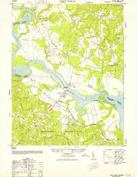 1952 Port Royal1952 Print · USGSThe Rappahannock River separates historic river towns and expanding military grounds in the early 1950s. Genealogists can trace family landmarks and rural life through Port Royal, the Welcome School, and Immanuel Church.
Showing maps 1-25 of 56
Top cities of King George County
- King George historical maps
- Dahlgren historical maps
- Passapatanzy historical maps
- Dahlgren Center historical maps
- Fairview Beach historical maps
Frequently asked questions
- What are the different types of historical maps available for King George County?
- What is the oldest map of King George County?
- Where can I purchase historical maps of King George County for my home or office?
- Where can I download high-res historical maps of King George County?
- Are there historical topographic maps available for King George County?
- Is there historical aerial imagery available for King George County?
- Where are historical maps of King George County sourced from?