1940s Maps of Collier Mill, Virginia
Explore 2 historic maps of Collier Mill from the 1940s. These maps offer a rare glimpse into what life looked like during the 1940s — showing old roads, neighborhoods, homes, and landmarks that have changed or disappeared over time.
Whether you're researching your family's past, planning a metal detecting trip, or studying how Collier Mill's landscape evolved across the 1940s, these high-resolution maps are a powerful tool for exploring the history of this region.
- Focus on a specific era: All maps on this page are from the 1940s, giving you a focused view of this time period.
- See what’s changed: Compare century-old streets, trails, and buildings to today's modern landscape using overlays and satellite layers.
- Research with precision: Use these maps for genealogy, historical research, land use analysis, or educational projects.
- View, download, or print: Maps are fully viewable online in high resolution, and can be downloaded or printed for your own records.
Start exploring Collier Mill's history through authentic maps from the 1940s. This is your window into the past.
Collier Mill, VA maps
(2)- 1947 Map of Ben Hur, 1960 Print
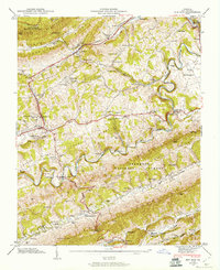 1947 Ben Hur1960 Print · USGSLee County in the late 1940s reveals a mountain landscape defined by the Powell River and the winding Louisville and Nashville railroad. Genealogists can trace family names across Waddell Cem and Hyden Cem, or locate landmarks like Collier Mill and Poteet Ferry Bridge.4 unique versions available
 - 1949 Map of Ben Hur
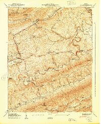 1949 Ben Hur1949 Print · USGSLee County, Virginia, in the late Forties is a landscape of mountain ridges and river crossings where the Louisville and Nashville rail line links valley settlements. Genealogists can trace family names across dozens of sites like McConnell Chapel, Ely Cem, and Waddell Cem.
End of results
Showing maps 1-2 of 2
Top cities near Collier Mill
- Big Stone Gap historical maps
- Pennington Gap historical maps
- Surgoinsville historical maps
- Appalachia historical maps
- Sneedville historical maps
- Dryden historical maps
See more
Frequently asked questions
- What are the different types of historical maps available for Collier Mill?
- What is the oldest map of Collier Mill?
- Where can I purchase historical maps of Collier Mill for my home or office?
- Where can I download high-res historical maps of Collier Mill?
- Are there historical topographic maps available for Collier Mill?
- Is there historical aerial imagery available for Collier Mill?
- Where are historical maps of Collier Mill sourced from?