1940s Maps of Greene Mill Preserve, Loudoun County
Explore 5 historic maps of Greene Mill Preserve from the 1940s. These maps offer a rare glimpse into what life looked like during the 1940s — showing old roads, neighborhoods, homes, and landmarks that have changed or disappeared over time.
Whether you're researching your family's past, planning a metal detecting trip, or studying how Greene Mill Preserve's landscape evolved across the 1940s, these high-resolution maps are a powerful tool for exploring the history of this region.
- Focus on a specific era: All maps on this page are from the 1940s, giving you a focused view of this time period.
- See what’s changed: Compare century-old streets, trails, and buildings to today's modern landscape using overlays and satellite layers.
- Research with precision: Use these maps for genealogy, historical research, land use analysis, or educational projects.
- View, download, or print: Maps are fully viewable online in high resolution, and can be downloaded or printed for your own records.
Start exploring Greene Mill Preserve's history through authentic maps from the 1940s. This is your window into the past.
Greene Mill Preserve, Loudoun County maps
(5)- 1943 Map of Arcola, 1957 Print
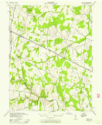 1943 Arcola1957 Print · USGSNorthern Virginia remains a landscape of quiet crossroads and family farms during the mid-1940s. Genealogists can trace rural life through landmarks like Watson Sch, Conklin Ch, and the small settlement of Lenah along the Lee-Jackson Memorial Highway.3 unique versions available
 - 1944 Map of Leesburg
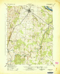 1944 Leesburg1944 Print · USGSLoudoun County, Virginia, is captured in the mid-1940s as a landscape of crossroads, mills, and riverside farms. Genealogists and historians can trace old homesteads and landmarks like Oatlands, the Prison Labor Camp No 2, and the C & O Canal (Abandoned).
 - 1944 Map of Arcola
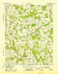 1944 Arcola1944 Print · USGSNorthern Virginia was a landscape of quiet crossroads and rural parishes during the mid-forties. Genealogists and local historians can trace family roots through landmarks like Watson-Sch, Mt Zion Ch, and the small settlement of Arcola.
 - 1948 Map of Baltimore
 1948 Baltimore1948 Print · USGSMaryland and Pennsylvania crossroads are captured in the late 1940s, showing a landscape defined by historic rail lines and major military installations. Genealogists can trace family connections in Gettysburg, Westminster, and near the U.S. Naval Academy in Annapolis.2 unique versions available
 - 1948 Map of Washington
 1948 Washington1948 Print · USGSThe Potomac and Chesapeake regions in the late 1940s reveal a landscape of expanding military reach and deep-rooted Tidewater settlements. Trace old rail corridors like the Richmond Fredericksburg & Potomac RR or locate landmarks like the Wakefield Washington Monument and St. Marys College.2 unique versions available
End of results
Showing maps 1-5 of 5
Frequently asked questions
- What are the different types of historical maps available for Greene Mill Preserve?
- What is the oldest map of Greene Mill Preserve?
- Where can I purchase historical maps of Greene Mill Preserve for my home or office?
- Where can I download high-res historical maps of Greene Mill Preserve?
- Are there historical topographic maps available for Greene Mill Preserve?
- Is there historical aerial imagery available for Greene Mill Preserve?
- Where are historical maps of Greene Mill Preserve sourced from?