1900s (20th Century) Maps of Martinsville, Virginia
Explore 11 historic maps of Martinsville from the 1900s (20th Century). These maps offer a rare glimpse into what life looked like during the 1900s — showing old roads, neighborhoods, homes, and landmarks that have changed or disappeared over time.
Whether you're researching your family's past, planning a metal detecting trip, or studying how Martinsville's landscape evolved across the 1900s, these high-resolution maps are a powerful tool for exploring the history of this region.
- Focus on a specific era: All maps on this page are from the 1900s, giving you a focused view of this time period.
- See what’s changed: Compare century-old streets, trails, and buildings to today's modern landscape using overlays and satellite layers.
- Research with precision: Use these maps for genealogy, historical research, land use analysis, or educational projects.
- View, download, or print: Maps are fully viewable online in high resolution, and can be downloaded or printed for your own records.
Start exploring Martinsville's history through authentic maps from the 1900s. This is your window into the past.
Martinsville, VA maps
(11)- 1924 Map of Martinsville
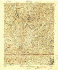
 1924 Martinsville1924 Print · USGSHenry County is shown in the mid-twenties as a thriving industrial corridor along the Smith River. Genealogists can trace family roots through dozens of rural landmarks, from the Bough and Reilly Mill to the Mountain School and Rock Run Church.
 - 1926 Map of Martinsville
 1926 Martinsville1926 Print · USGSHenry County and the Virginia-North Carolina border are captured in the mid-1920s, a period when the Smith River and twin rail lines drove local industry. Researchers can locate dozens of family-named landmarks and institutions like Rough and Ready Mill, Rangeleys Store, and Horse Pasture Church.2 unique versions available
 - 1927 Map of Martinsville, 1942 Print
 1927 Martinsville1942 Print · USGSHenry County and the Virginia-North Carolina border are captured here during the mid-twenties, when the textile and rail economy was transforming the Piedmont. Researchers can trace family sites among dozens of landmarks like Rough and Ready Mill, Fieldale, and Rock Run Church.2 unique versions available
 - 1944 Map of Martinsville
 1944 Martinsville1944 Print · USGSHenry County is captured in the mid-1940s as a thriving center of industry and agriculture along the Smith River. Genealogists and historians can trace family locations near dozens of rural landmarks like Rough and Ready Mill, Cedar Chappell, and the County Farm.
 - 1953 Map of Greensboro, 1981 Print
 1953 Greensboro1981 Print · USGSThe Piedmont borderlands of North Carolina and Virginia show a landscape defined by new reservoirs and old rail lines. Trace family roots and the changing river geography through Elon College, the John H Kerr Reservoir, and South Boston.
 - 1954 Map of Greensboro
 1954 Greensboro1954 Print · USGSThe Piedmont borderlands of North Carolina and Virginia come alive in this mid-fifties study of a region defined by its rivers and rails. Researchers can trace the growing Buggs Island Lake or follow the paths of the Southern Ry and Seaboard Air Line RR through towns like Oxford and Reidsville.
 - 1962 Map of Greensboro
 1962 Greensboro1962 Print · USGSThe Piedmont region along the Virginia and North Carolina border comes alive in the early 1960s, showing a landscape defined by industry and new reservoirs. Trace the path of the Virginian RR or explore the early development of Greensboro and Durham.
 - 1964 Map of Martinsville East, 1966 Print
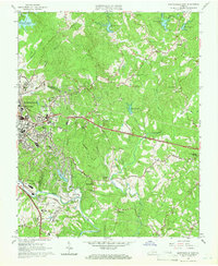 1964 Martinsville East1966 Print · USGSMartinsville and the Smith River valley appear here in the mid-sixties during a decade of regional expansion and institutional growth. Researchers can locate family-named landmarks like Barrow Cem, historic settlements such as Old Liberty, and the original Martinsville Speedway.5 unique versions available
 - 1965 Map of Martinsville West, 1966 Print
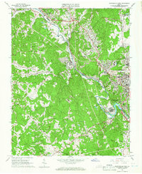 1965 Martinsville West1966 Print · USGSHenry County and the city of Martinsville were thriving industrial hubs in the mid-sixties, centered on the winding Smith River and its critical rail corridors. Researchers can trace local heritage through landmarks like Oakwood Cemetery, the Carver Sch, and rural crossroads such as Horse Pasture.5 unique versions available
 - 1966 Map of Greensboro
 1966 Greensboro1966 Print · USGSThe North Carolina and Virginia Piedmont thrives during the mid-sixties, showcasing a landscape of textile hubs and expanding river reservoirs. Researchers can trace the rail corridors of the Southern Railway, find local landmarks like Elon College, or locate the extensive Camp Butner Military Reservation.
 - 1984 Map of Danville
 1984 Danville1984 Print · USGSThe Virginia and North Carolina borderlands in the mid-1980s reveal a landscape of industrial river towns and rural Piedmont crossroads. Genealogists and historians can trace family sites near Highland Burial Park, find local landmarks like the Patrick Henry Monument, and locate old settlements like Callands or Milton.
End of results
Showing maps 1-11 of 11
Top cities of Martinsville
Frequently asked questions
- What are the different types of historical maps available for Martinsville?
- What is the oldest map of Martinsville?
- Where can I purchase historical maps of Martinsville for my home or office?
- Where can I download high-res historical maps of Martinsville?
- Are there historical topographic maps available for Martinsville?
- Is there historical aerial imagery available for Martinsville?
- Where are historical maps of Martinsville sourced from?