Old Maps of Norview Gardens, Virginia for Metal Detecting
Plan your next treasure hunt with 13 historic maps of Norview Gardens. Find old homesites, ghost towns, trails, and gathering spots that may be lost to time — perfect for identifying promising metal detecting locations.
- Locate forgotten sites: Uncover places like long-lost settlements, abandoned rail lines, or gathering spots.
- Plan better hunts: Use map overlays combined with LiDAR or satellite views to narrow in on historically rich areas.
- Made for detectorists: Thousands of hobbyists use these maps to discover relics, coins, and hidden history.
Use these historic maps to boost your research and find new opportunities beneath the surface of Norview Gardens.
Norview Gardens, VA maps
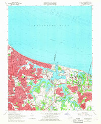
(13)- 1907 Map of Norfolk
 1907 Norfolk1907 Print · USGSCoastal Virginia is mapped here at the dawn of the twentieth century, during the bustle of the great Jamestown Exposition. Researchers can trace the early rail-and-canal economy through the Albemarle and Chesapeake Canal, the Navy Yard, and historic outposts like the Cape Henry Light.
 - 1918 Map of Cape Henry, 1961 Print
 1918 Cape Henry1961 Print · USGSThe Virginia coast at the close of the First World War shows a landscape of tidal inlets and rail-dependent settlements before modern expansion. Researchers can locate early landmarks like Old Donation Church, London Bridge, and the Dam Neck Mills.
 - 1919 Map of Cape Henry
 1919 Cape Henry1919 Print · USGSIn the years following the Great War, the Virginia coast was a mix of quiet truck farms and emerging resorts. Researchers can trace ancestral lands through dozens of named crossroads like Kempsville and Oceana, or find old houses of worship such as Old Donation Church.7 unique versions available
 - 1948 Map of Ocean View
 1948 Ocean View1948 Print · USGSChesapeake Bay's shoreline in the late 1940s is a landscape defined by military bases and growing coastal neighborhoods. Researchers can trace local landmarks like Diamond Springs, Little Creek Mine Base, and the original footprint of Norfolk Airport.
 - 1953 Map of Norfolk, 1954 Print
 1953 Norfolk1954 Print · USGSCoastal Virginia and northeastern North Carolina appear here during the post-war industrial boom, showing the critical rail-and-sea connections of Hampton Roads. Genealogists can trace family roots through rural landmarks like Gethsemane Ch, the Caledonia State Prison Farm, and the vast interior of the Dismal Swamp.4 unique versions available
 - 1954 Map of Ocean View, 1958 Print
 1954 Ocean View1958 Print · USGSCoastal Virginia in the mid-fifties shows a landscape of rapid growth where the City of Norfolk pushes into the countryside. Genealogists and historians can trace the development of neighborhoods like Camellia Shores and Brandon Place near the Norfolk Municipal Airport.
 - 1964 Map of Little Creek, 1968 Print
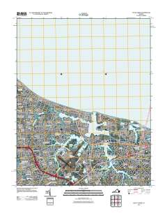
 1964 Little Creek1968 Print · USGSVirginia's coastline during the mid-sixties reveals a period of intense military and suburban growth along the Chesapeake. Genealogists and historians can trace neighborhood development in Ocean View and locate military landmarks like the Little Creek Amphibious Base.5 unique versions available
 - 1985 Map of Norfolk, 1986 Print
 1985 Norfolk1986 Print · USGSThe Tidewater region in the mid-eighties shows the dense urban expansion of the coastal cities alongside the preservation of the Great Dismal Swamp. Researchers can trace rural family-named crossroads and historic transit routes like the Seaboard Coast Line or find Somerton and Lake Drummond.3 unique versions available
 - 2011 Map of Little Creek, 2011 Print
 2011 Little Creek2011 Print · USGSCovers Norview Gardens, including Brandon Place, Forest Park, and other nearby areas
 - 2013 Map of Little Creek, 2013 Print
 2013 Little Creek2013 Print · USGSCovers Norview Gardens, including Brandon Place, Forest Park, and other nearby areas
 - 2016 Map of Little Creek, 2016 Print
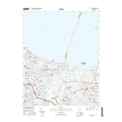 2016 Little Creek2016 Print · USGSCovers Norview Gardens, including Brandon Place, Forest Park, and other nearby areas
 - 2019 Map of Little Creek, 2019 Print
 2019 Little Creek2019 Print · USGSCovers Norview Gardens, including Brandon Place, Forest Park, and other nearby areas
 - 2022 Map of Little Creek, 2022 Print
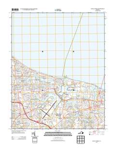
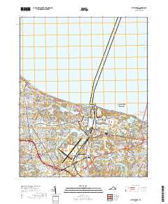
 2022 Little Creek2022 Print · USGSCoastal Virginia in the early 2020s shows a sophisticated landscape of maritime industry and residential growth between the bay and the airport. Genealogists and local historians can trace neighborhood boundaries from Ocean View to East Norview, alongside landmarks like Lake Smith and Fishermans Cove.
End of results
Showing maps 1-13 of 13
Top cities near Norview Gardens
- Chesapeake historical maps
- Norfolk historical maps
- Newport News historical maps
- Hampton historical maps
- Portsmouth historical maps
- Bethel Manor historical maps
Frequently asked questions
- What are the different types of historical maps available for Norview Gardens?
- What is the oldest map of Norview Gardens?
- Where can I purchase historical maps of Norview Gardens for my home or office?
- Where can I download high-res historical maps of Norview Gardens?
- Are there historical topographic maps available for Norview Gardens?
- Is there historical aerial imagery available for Norview Gardens?
- Where are historical maps of Norview Gardens sourced from?