1960s Maps of Nassawadox, Virginia
Explore 3 historic maps of Nassawadox from the 1960s. These maps offer a rare glimpse into what life looked like during the 1960s — showing old roads, neighborhoods, homes, and landmarks that have changed or disappeared over time.
Whether you're researching your family's past, planning a metal detecting trip, or studying how Nassawadox's landscape evolved across the 1960s, these high-resolution maps are a powerful tool for exploring the history of this region.
- Focus on a specific era: All maps on this page are from the 1960s, giving you a focused view of this time period.
- See what’s changed: Compare century-old streets, trails, and buildings to today's modern landscape using overlays and satellite layers.
- Research with precision: Use these maps for genealogy, historical research, land use analysis, or educational projects.
- View, download, or print: Maps are fully viewable online in high resolution, and can be downloaded or printed for your own records.
Start exploring Nassawadox's history through authentic maps from the 1960s. This is your window into the past.
Nassawadox, VA maps
(3)- 1961 Map of Eastville
 1961 Eastville1961 Print · USGSThe Eastern Shore and Outer Banks are captured here in the mid-twentieth century, showing a maritime landscape of lighthouses, rail-linked towns, and naval outposts. Researchers can trace the Pennsylvania Railroad through Parksley or locate historical sites like Chincoteague Field Naval Auxiliary Air Station and Tangier Island.
 - 1966 Map of Eastville
 1966 Eastville1966 Print · USGSThe Delmarva Peninsula and Outer Banks appear in the mid-sixties, showing a landscape of maritime trade, military outposts, and fishing villages. Researchers can trace the lines of the Norfolk & Southern through Exmore and Parksley or locate historical sites like Fort John Custis and the Janes Island Lighthouse.
 - 1968 Map of Nassawadox, 1971 Print
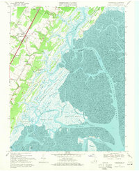 1968 Nassawadox1971 Print · USGSThe Virginia Eastern Shore in the late sixties reveals a landscape of railroad towns and sprawling saltwater marshes. Genealogists can trace family roots through Little Johnsontown and Hare Valley, or locate landmarks like Red Bank Ch.2 unique versions available
End of results
Showing maps 1-3 of 3
Top cities near Nassawadox
- Exmore historical maps
- Cape Charles historical maps
- Onancock historical maps
- Onley historical maps
- Cheriton historical maps
- Boston historical maps
See more
Frequently asked questions
- What are the different types of historical maps available for Nassawadox?
- What is the oldest map of Nassawadox?
- Where can I purchase historical maps of Nassawadox for my home or office?
- Where can I download high-res historical maps of Nassawadox?
- Are there historical topographic maps available for Nassawadox?
- Is there historical aerial imagery available for Nassawadox?
- Where are historical maps of Nassawadox sourced from?