1910s Maps of Northumberland County, Virginia
Explore 7 historic maps of Northumberland County from the 1910s. These maps offer a rare glimpse into what life looked like during the 1910s — showing old roads, neighborhoods, homes, and landmarks that have changed or disappeared over time.
Whether you're researching your family's past, planning a metal detecting trip, or studying how Northumberland County's landscape evolved across the 1910s, these high-resolution maps are a powerful tool for exploring the history of this region.
- Focus on a specific era: All maps on this page are from the 1910s, giving you a focused view of this time period.
- See what’s changed: Compare century-old streets, trails, and buildings to today's modern landscape using overlays and satellite layers.
- Research with precision: Use these maps for genealogy, historical research, land use analysis, or educational projects.
- View, download, or print: Maps are fully viewable online in high resolution, and can be downloaded or printed for your own records.
Start exploring Northumberland County's history through authentic maps from the 1910s. This is your window into the past.
Northumberland County, VA maps
(7)- 1912 Map of Point Lookout
 1912 Point Lookout1912 Print · USGSSouthern St. Mary's County appears here just after the turn of the century, showing a waterfront economy dependent on the river and bay. Genealogists and historians can trace family landings at Broomes Wharf and Miller Wharf or locate old settlements like St Inigoes and Great Mills.2 unique versions available
 - 1916 Map of Kilmarnock
 1916 Kilmarnock1916 Print · USGSBefore the era of modern bridges, this coastal Virginia region relied on a busy steamboat route network connecting the Northern Neck and Middle Peninsula. Genealogists can locate family landmarks like Wharton Grove Camp, White Chapel Church, and numerous landings including Morattico Wharf.2 unique versions available
 - 1917 Map of Heathsville
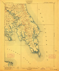
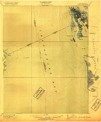
 1917 Heathsville1917 Print · USGSNorthumberland County's peninsulas and maritime crossroads are intricately detailed here during the late 1910s. Local researchers can trace family roots through historic landmarks like Macedonia Church, Coan Hall School, and the busy waters of the Steamboat Route at Reedville.4 unique versions available
 - 1917 Map of Morattico
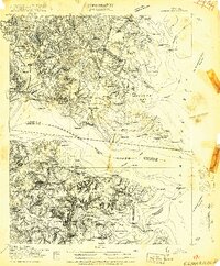
 1917 Morattico1917 Print · USGSThe Northern Neck of Virginia is shown here in the years before the Great War, when the Rappahannock River was a busy Steamboat Route. Genealogists can locate family landmarks like Gordys Millpond, Lively, and the Marvin Grove Camp in this detailed look at early rural life.
 - 1917 Map of Kilmarnock
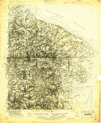
 1917 Kilmarnock1917 Print · USGSThe Northern Neck and Middle Peninsula of Virginia are shown during the height of the steamboat era. Genealogists can locate family-named landmarks and essential community hubs like the Old Brick Church, Harmony Village, and Kilmarnock Wharf.4 unique versions available
 - 1917 Map of Ewell
 1917 Ewell1917 Print · USGSIsolated island life in the Chesapeake comes into focus during the early twentieth century. Researchers can trace the original footprints of Ewell, Rhodes Point, and Tangier, alongside maritime landmarks like the Smith Point LH and old Steamboat Routes.2 unique versions available
 - 1918 Map of Morattico
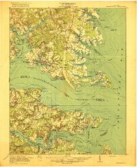
 1918 Morattico1918 Print · USGSThe Northern Neck region relied heavily on the Rappahannock waterfront during the early twentieth century, when steamboats were still the primary connection to the outside world. Researchers can trace ancestral home sites and community centers from Lodge and Nuttsville to historic landmarks like Gibeon Church and Downings Mill.3 unique versions available
End of results
Showing maps 1-7 of 7
Top cities of Northumberland County
Frequently asked questions
- What are the different types of historical maps available for Northumberland County?
- What is the oldest map of Northumberland County?
- Where can I purchase historical maps of Northumberland County for my home or office?
- Where can I download high-res historical maps of Northumberland County?
- Are there historical topographic maps available for Northumberland County?
- Is there historical aerial imagery available for Northumberland County?
- Where are historical maps of Northumberland County sourced from?