1960s Maps of Orange County, Virginia
Explore 14 historic maps of Orange County from the 1960s. These maps offer a rare glimpse into what life looked like during the 1960s — showing old roads, neighborhoods, homes, and landmarks that have changed or disappeared over time.
Whether you're researching your family's past, planning a metal detecting trip, or studying how Orange County's landscape evolved across the 1960s, these high-resolution maps are a powerful tool for exploring the history of this region.
- Focus on a specific era: All maps on this page are from the 1960s, giving you a focused view of this time period.
- See what’s changed: Compare century-old streets, trails, and buildings to today's modern landscape using overlays and satellite layers.
- Research with precision: Use these maps for genealogy, historical research, land use analysis, or educational projects.
- View, download, or print: Maps are fully viewable online in high resolution, and can be downloaded or printed for your own records.
Start exploring Orange County's history through authentic maps from the 1960s. This is your window into the past.
Orange County, VA maps
(14)- 1961 Map of Washington
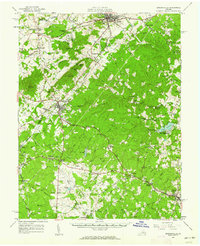
 1961 Washington1961 Print · USGSThe mid-Atlantic region in the late fifties is presented in remarkable detail, from the Blue Ridge foothills to the Chesapeake Eastern Shore. Researchers can trace historic river landings and military sites like Mount Vernon, Fort Belvoir, and Point Lookout.2 unique versions available
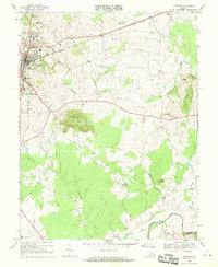
 - 1961 Map of Gordonsville, 1962 Print
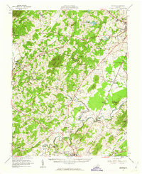
 1961 Gordonsville1962 Print · USGSCentral Virginia in the early sixties remains a landscape of deep historical roots and rail-based commerce. Genealogists and researchers can trace family names through landmarks like Boswells Tavern, the James Madison Grave, and rural sites like Liberty Mills.2 unique versions available
 - 1961 Map of Rapidan, 1963 Print
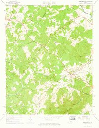
 1961 Rapidan1963 Print · USGSMadison and Culpeper Counties during the early sixties show a transition from a traditional mill-based economy to a modern rural landscape. Genealogists can trace family names at Waylands Mill, Achsah, and Thorofare Mtn Chapel along the Piedmont rivers.2 unique versions available
 - 1964 Map of Barboursville, 1965 Print
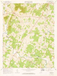
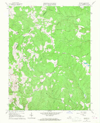
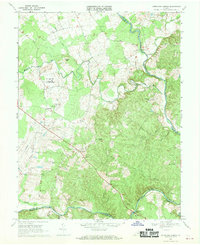
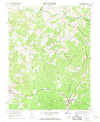
 1964 Barboursville1965 Print · USGSThe Virginia Piedmont near Barboursville comes alive in the mid-1960s, showing a landscape of railroad hamlets and rural mountain ridges. Genealogists can trace family landmarks like Thomas Cem and Knights Chapel or explore the Barbour Ruins near the Southern rail line.4 unique versions available
 - 1964 Map of Rochelle, 1966 Print
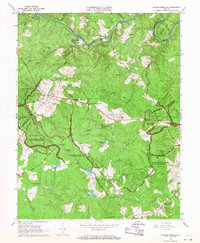
 1964 Rochelle1966 Print · USGSIn the foothills of the Blue Ridge during the mid-sixties, this area shows a network of established crossroads communities and mountain ridges. Trace the location of family landmarks and local institutions like Repton Mills, Pleasant Grove Ch, and Dawsonville.4 unique versions available
 - 1966 Map of Belmont, 1967 Print
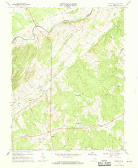
 1966 Belmont1967 Print · USGSMid-century central Virginia comes into focus across the Orange and Spotsylvania county lines during the late sixties. Genealogists and local historians can trace family-named sites like Bells Crossroad, Richards Shop, and several country churches including Craigs Ch.4 unique versions available
 - 1966 Map of Chancellorsville, 1968 Print
 1966 Chancellorsville1968 Print · USGSSpotsylvania County is shown here in the mid-sixties, where the preserved Civil War battlefields meet the quiet rural life of the Virginia Piedmont. Genealogists and historians can locate markers like Hamiltons Thicket, the Jackson Furnace ruins, and family-named landmarks such as Elys Ford.
 - 1968 Map of Unionville, 1970 Print
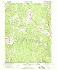
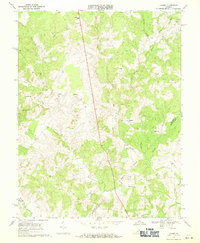
 1968 Unionville1970 Print · USGSOrange County in the late 1960s remains a landscape of rolling Piedmont farms and river crossings along the Rapidan River. Genealogists and historians can trace family locations near Sleets Shop, Bledsoe Corner, and the Old Railroad Grade.3 unique versions available
 - 1968 Map of Richardsville, 1970 Print
 1968 Richardsville1970 Print · USGSUpper Piedmont life in the late sixties is centered around the confluence of the Rappahannock River and Rapidan River. Genealogists and local historians can locate rural landmarks such as Goldvein, Richardsville, and Clevers Oak Ch.3 unique versions available
 - 1968 Map of Germanna Bridge, 1970 Print
 1968 Germanna Bridge1970 Print · USGSIn the late sixties, the river country between Culpeper and Fauquier counties remained a landscape of rural stores and strategic river crossings. You can trace family roots and old routes through Kellys Ford, Lignum, and the family-named Edwards Shop.2 unique versions available
 - 1968 Map of Culpeper, 1970 Print
 1968 Culpeper1970 Print · USGSCulpeper and its surrounding rural communities are captured here in the late sixties, just before the expansion of the modern era. Researchers can trace local genealogy and land use through landmarks like Stevensburg, the National Cem, and St Stephens Ch.
 - 1968 Map of Lahore, 1971 Print
 1968 Lahore1971 Print · USGSCentral Virginia's rural landscape is captured here in the late sixties at the meeting point of Orange, Spotsylvania, and Louisa counties. Genealogists can trace the locations of family landmarks and community centers like Lightfoot Sch, Bethel Ch, and the settlement of Lahore.3 unique versions available
 - 1969 Map of Mine Run, 1971 Print
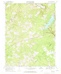 1969 Mine Run1971 Print · USGSOrange County's rural crossroads and Civil War legacy are documented here during a period of modern growth in the late sixties. Researchers can trace the Wilderness Battlefield and locate old landmarks like Gold Dale or Mt Zion Ch.3 unique versions available
 - 1969 Map of Mineral, 1971 Print
 1969 Mineral1971 Print · USGSThe Piedmont landscape of Louisa County comes into focus in the late sixties, showcasing the rail-connected hubs of Mineral and Louisa. Researchers can trace the path of the Chesapeake and Ohio or locate rural landmarks like Dickinson Store and Enon Ch.5 unique versions available
End of results
Showing maps 1-14 of 14
Top cities of Orange County
- Lake of the Woods historical maps
- Orange historical maps
- Gordonsville historical maps
- Barboursville historical maps
Frequently asked questions
- What are the different types of historical maps available for Orange County?
- What is the oldest map of Orange County?
- Where can I purchase historical maps of Orange County for my home or office?
- Where can I download high-res historical maps of Orange County?
- Are there historical topographic maps available for Orange County?
- Is there historical aerial imagery available for Orange County?
- Where are historical maps of Orange County sourced from?