1950s Maps of Poquoson, Virginia
Explore 5 historic maps of Poquoson from the 1950s. These maps offer a rare glimpse into what life looked like during the 1950s — showing old roads, neighborhoods, homes, and landmarks that have changed or disappeared over time.
Whether you're researching your family's past, planning a metal detecting trip, or studying how Poquoson's landscape evolved across the 1950s, these high-resolution maps are a powerful tool for exploring the history of this region.
- Focus on a specific era: All maps on this page are from the 1950s, giving you a focused view of this time period.
- See what’s changed: Compare century-old streets, trails, and buildings to today's modern landscape using overlays and satellite layers.
- Research with precision: Use these maps for genealogy, historical research, land use analysis, or educational projects.
- View, download, or print: Maps are fully viewable online in high resolution, and can be downloaded or printed for your own records.
Start exploring Poquoson's history through authentic maps from the 1950s. This is your window into the past.
Poquoson, VA maps
(5)- 1955 Map of Morrison, 1958 Print
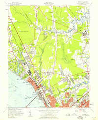 1955 Morrison1958 Print · USGSMid-century development spreads across the Virginia Peninsula in the years following the war, bridging the gap between old battlefields and new suburbs. Genealogists and historians can trace neighborhood growth through Hilton Village, Aberdeen Garden, and the location of Blooming Zion Ch.
 - 1955 Map of Harris Grove, 1958 Print
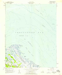
 1955 Harris Grove1958 Print · USGSThe Virginia Peninsula is captured here in the mid-fifties, showing the coastal necks and historical grounds around the York River. Genealogists and historians can trace the footprint of Yorktown Battlefield, the community of Poquoson, and local landmarks like Moore House.
 - 1955 Map of Messick, 1958 Print
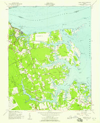
 1955 Messick1958 Print · USGSCoastal York County in the mid-fifties is defined by the intersection of military zones and small tidewater communities. Local historians can trace the early layout of Poquoson and Messick alongside the Plum Tree Island Bombing Range and the lonely York Spit Lighthouse.
 - 1955 Map of Hampton, 1958 Print
 1955 Hampton1958 Print · USGSHampton and the tip of the Virginia Peninsula are shown here during the mid-fifties, dominated by military installations and bayfront communities. Genealogists and historians can trace neighborhood growth in Pleasant Manor, locate the Western Cem, or study the grounds of Hampton Institute and Fort Monroe.
 - 1959 Map of Richmond
 1959 Richmond1959 Print · USGSMid-century Virginia is captured here at its most vital rail and river junctions, from the capital city to the Chesapeake Bay. Genealogists and historians can trace the development of colonial settlements like Williamsburg and military landmarks including Fort Monroe and Camp Lee.
End of results
Showing maps 1-5 of 5
Top cities of Poquoson
Frequently asked questions
- What are the different types of historical maps available for Poquoson?
- What is the oldest map of Poquoson?
- Where can I purchase historical maps of Poquoson for my home or office?
- Where can I download high-res historical maps of Poquoson?
- Are there historical topographic maps available for Poquoson?
- Is there historical aerial imagery available for Poquoson?
- Where are historical maps of Poquoson sourced from?