1960s Maps of Goshen, Virginia
Explore 4 historic maps of Goshen from the 1960s. These maps offer a rare glimpse into what life looked like during the 1960s — showing old roads, neighborhoods, homes, and landmarks that have changed or disappeared over time.
Whether you're researching your family's past, planning a metal detecting trip, or studying how Goshen's landscape evolved across the 1960s, these high-resolution maps are a powerful tool for exploring the history of this region.
- Focus on a specific era: All maps on this page are from the 1960s, giving you a focused view of this time period.
- See what’s changed: Compare century-old streets, trails, and buildings to today's modern landscape using overlays and satellite layers.
- Research with precision: Use these maps for genealogy, historical research, land use analysis, or educational projects.
- View, download, or print: Maps are fully viewable online in high resolution, and can be downloaded or printed for your own records.
Start exploring Goshen's history through authentic maps from the 1960s. This is your window into the past.
Goshen, VA maps
(4)- 1963 Map of Roanoke
 1963 Roanoke1963 Print · USGSCentral Virginia and the Blue Ridge front appear here in the early sixties, caught between their deep railroad roots and new postwar developments. Genealogists and historians can trace the rail lines of the Norfolk and Western through towns like Bedford and Altavista, or locate family landmarks near Smith Mountain Lake.
 - 1967 Map of Goshen, 1979 Print
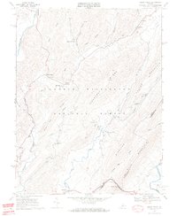
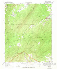
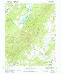 1967 Goshen1979 Print · USGSRockbridge County's mountain passes and river valleys are captured here in the late sixties, just as recreational camps expanded around Lake Merriweather. Researchers can locate historic rural centers like Rockbridge Baths, Cedar Grove, and Bethesda Ch.3 unique versions available
 - 1969 Map of Green Valley, 1970 Print
 1969 Green Valley1970 Print · USGSBath County's mountain gaps and river valleys are shown here in the late sixties as the region maintained its rural character. Genealogists can locate family landmarks like McCowan Spring, Cloverdale Ch, and the small settlement of Armstrong.5 unique versions available
 - 1969 Map of Millboro, 1971 Print
 1969 Millboro1971 Print · USGSVirginia's mountain gaps and railroad corridors are captured here in the late sixties, showing the rugged divide between Bath and Rockbridge counties. Researchers can trace historic sites like Rockbridge Alum Springs, the Millboro Tunnel, and the remote community of California.3 unique versions available
End of results
Showing maps 1-4 of 4
Top cities near Goshen
Frequently asked questions
- What are the different types of historical maps available for Goshen?
- What is the oldest map of Goshen?
- Where can I purchase historical maps of Goshen for my home or office?
- Where can I download high-res historical maps of Goshen?
- Are there historical topographic maps available for Goshen?
- Is there historical aerial imagery available for Goshen?
- Where are historical maps of Goshen sourced from?