1980s Maps of Montezuma, Virginia
Explore 2 historic maps of Montezuma from the 1980s. These maps offer a rare glimpse into what life looked like during the 1980s — showing old roads, neighborhoods, homes, and landmarks that have changed or disappeared over time.
Whether you're researching your family's past, planning a metal detecting trip, or studying how Montezuma's landscape evolved across the 1980s, these high-resolution maps are a powerful tool for exploring the history of this region.
- Focus on a specific era: All maps on this page are from the 1980s, giving you a focused view of this time period.
- See what’s changed: Compare century-old streets, trails, and buildings to today's modern landscape using overlays and satellite layers.
- Research with precision: Use these maps for genealogy, historical research, land use analysis, or educational projects.
- View, download, or print: Maps are fully viewable online in high resolution, and can be downloaded or printed for your own records.
Start exploring Montezuma's history through authentic maps from the 1980s. This is your window into the past.
Montezuma, VA maps
(2)- 1986 Map of Charlottesville
 1986 Charlottesville1986 Print · USGSCentral Virginia in the mid-eighties shows a landscape balanced between the growing city centers of the Piedmont and the protected ridges of the Blue Ridge. Trace the historic rail lines of the Chesapeake and Ohio Railway or locate local landmarks like Monticello Mountain and Bridgewater College.3 unique versions available
 - 1989 Map of Bridgewater, 1995 Print
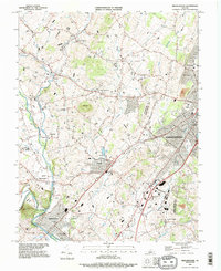 1989 Bridgewater1995 Print · USGSRockingham County in the late eighties shows a landscape shaped by collegiate growth and deep-rooted agricultural hamlets. Genealogists and historians can trace family sites near Montezuma, local landmarks like Silver Lake, or the grounds of Bridgewater College.
End of results
Showing maps 1-2 of 2
Top cities near Montezuma
- Harrisonburg historical maps
- Massanetta Springs historical maps
- Bridgewater historical maps
- Verona historical maps
- Broadway historical maps
- Weyers Cave historical maps
See more
Frequently asked questions
- What are the different types of historical maps available for Montezuma?
- What is the oldest map of Montezuma?
- Where can I purchase historical maps of Montezuma for my home or office?
- Where can I download high-res historical maps of Montezuma?
- Are there historical topographic maps available for Montezuma?
- Is there historical aerial imagery available for Montezuma?
- Where are historical maps of Montezuma sourced from?