1930s Maps of Corn Valley, Virginia
Explore 1 historic maps of Corn Valley from the 1930s. These maps offer a rare glimpse into what life looked like during the 1930s — showing old roads, neighborhoods, homes, and landmarks that have changed or disappeared over time.
Whether you're researching your family's past, planning a metal detecting trip, or studying how Corn Valley's landscape evolved across the 1930s, these high-resolution maps are a powerful tool for exploring the history of this region.
- Focus on a specific era: All maps on this page are from the 1930s, giving you a focused view of this time period.
- See what’s changed: Compare century-old streets, trails, and buildings to today's modern landscape using overlays and satellite layers.
- Research with precision: Use these maps for genealogy, historical research, land use analysis, or educational projects.
- View, download, or print: Maps are fully viewable online in high resolution, and can be downloaded or printed for your own records.
Start exploring Corn Valley's history through authentic maps from the 1930s. This is your window into the past.
Corn Valley, VA maps
(1)- 1935 Map of Elk Garden
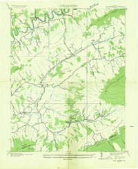 1935 Elk Garden1935 Print · USGSSouthwestern Virginia ridge country comes alive in the mid-1930s, showing the rural communities of Russell and Washington counties. Genealogists can locate family landmarks like Elway P O, Denniston Sch, and Sneads Chapel along the valley roads.
End of results
Showing maps 1-1 of 1
Top cities near Corn Valley
- Abingdon historical maps
- Richlands historical maps
- Lebanon historical maps
- Raven historical maps
- Saltville historical maps
- Glade Spring historical maps
See more
Frequently asked questions
- What are the different types of historical maps available for Corn Valley?
- What is the oldest map of Corn Valley?
- Where can I purchase historical maps of Corn Valley for my home or office?
- Where can I download high-res historical maps of Corn Valley?
- Are there historical topographic maps available for Corn Valley?
- Is there historical aerial imagery available for Corn Valley?
- Where are historical maps of Corn Valley sourced from?