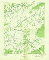
1935 Map of Elk Garden
USGS Topo · Published 1935About this map
Clinch River headwaters wind through a landscape defined by parallel ridges and narrow valleys in this 1935 field examination. The settlement pattern follows the valley floors, with small communities like Blackford and Elway serving as local hubs. Faith and education are central to the rural geography, evidenced by a high density of small institutions such as Sneads Chapel, Barnett Ch, and Elk Garden Sch. Transportation during the mid-1930s relied on the Norfolk and Western railroad corridor and the Lonesome Pine Trail, while the Appalachian Electric Power Company Transmission Line indicates the era's expanding infrastructure. The map clearly illustrates the transition from the high elevations of Beartown Mountain and Rich Mountain down to the agricultural pockets of Poor Valley.
Find a feature on this map
64 named features on this map. Tap any name to fly to it.
Don’t see what you’re looking for? This feature index may not catch every label — zoom into the map to look around manually.
Map Details
Editions of this 1935 Elk Garden Map
This is the sole edition of this map. No revisions or reprints were ever made.
Other maps of this area

1886 · Grundy
USGS Topo · 1:125,000

1890 · Grundy
USGS Topo · 1:125,000

1891 · Tazewell
USGS Topo · 1:125,000

1891 · Abingdon
USGS Topo · 1:125,000

1892 · Grundy
USGS Topo · 1:125,000

1894 · Abingdon
USGS Topo · 1:125,000

1895 · Tazewell
USGS Topo · 1:125,000

1897 · Tazewell
USGS Topo · 1:125,000

1897 · Bristol
USGS Topo · 1:125,000

1902 · Bristol
USGS Topo · 1:125,000