Old Maps of Hansonville, Virginia for Genealogy
Trace your family roots with 16 historic maps of Hansonville. These high-res maps reveal old neighborhoods, homesites, landmarks, and streets — helping you uncover where your ancestors lived and how the area evolved over time.
- Explore historic neighborhoods: Identify where your relatives may have lived in the 1800s or 1900s.
- Compare maps over time: Trace the changes in streets, buildings, and landmarks for multi-generational research.
- Perfect for genealogy & ancestry research: Used by family historians and researchers to map out lineage and migration.
These maps are an incredible resource for exploring your personal connection to Hansonville's past.
Hansonville, VA maps
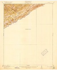
(16)- 1897 Map of Bristol
 1897 Bristol1897 Print · USGSThe Tennessee-Virginia borderlands in the late nineteenth century were a landscape of steep ridges and river-dependent commerce. Genealogists can trace family homesteads near Bickley Mill, locate river crossings like Childress Ferry, or find early rail stops along the Norfolk and Western RR.
 - 1902 Map of Bristol
 1902 Bristol1902 Print · USGSThe interstate border region around Bristol appears here at the start of the twentieth century, defined by its deep mountain ridges and river valleys. Researchers can trace the early industrial footprint of the area through numerous landmarks like Bickley Mill, Kings Mill, and the Norfolk and Western RR.6 unique versions available
 - 1918 Map of Carterton
 1918 Carterton1918 Print · USGSRussell County, Virginia, is defined by its steep coal-country ridges and the winding river corridor during the early twentieth century. Genealogists and researchers can trace the paths of the Norfolk and Western railway through Cleveland and locate vanished rural hubs like Musick School or Coulwood PO.3 unique versions available
 - 1934 Map of Hansonville
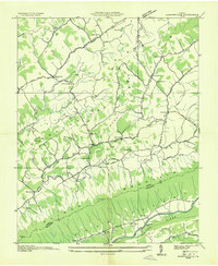 1934 Hansonville1934 Print · USGSThe rural communities of Russell County are shown during the mid-1930s as the Tennessee Valley Authority mapped the Appalachian valleys and ridges. Genealogists and historians can locate old schools and family-linked landmarks like Millers Mill, Hawkins Mill, and Adams Chapel.
 - 1938 Map of Hansonville, 1963 Print
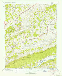 1938 Hansonville1963 Print · USGSSouthwest Virginia’s ridge-and-valley landscape is captured here in the late 1930s as local life centered on the forks of Moccasin Creek. Genealogists and historians can trace family locations near Hawkins Mill, the Davis Cemetery, and the Zenobia Post Office.3 unique versions available
 - 1939 Map of Hansonville
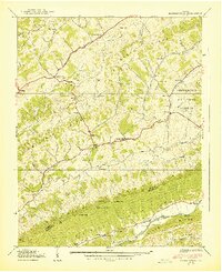 1939 Hansonville1939 Print · USGSThe rural valleys of Russell and Washington Counties are captured here in the late 1930s, showing a landscape of ridge-top trails and creek-side mills. Researchers can trace local history through sites like Zenobia PO, Miller Mill, and the McFadden Ford on the Holston River.2 unique versions available
 - 1955 Map of Johnson City
 1955 Johnson City1955 Print · USGSEast Tennessee and the bordering highlands of Virginia and Kentucky appear here during the post-war industrial boom. You can trace the complex network of mountain ridges and new TVA lakes, from Johnson City to the coalfields near Middlesboro and Lynch.
 - 1957 Map of Johnson City, 1966 Print
 1957 Johnson City1966 Print · USGSUpper East Tennessee and Southwest Virginia are shown here during the mid-sixties transition of the Appalachians. Researchers can trace the industrial rail hubs of Kingsport, the sprawling waters of Cherokee Lake, and the historic Cumberland Gap.
 - 1960 Map of Johnson City
 1960 Johnson City1960 Print · USGSUpper East Tennessee and the surrounding tri-state area are shown in the mid-fifties during the height of the TVA reservoir era. Trace the industrial rail lines of the Southern and Louisville and Nashville between Kingsport and Johnson City.
 - 1963 Map of Johnson City
 1963 Johnson City1963 Print · USGSThe Tri-Cities and the surrounding Appalachian ridges are shown in detail during the early sixties, highlighting the era's vital rail and river networks. Genealogists and historians can trace the routes of the Clinchfield RR and locate settlements from Rogersville to Elizabethton.
 - 1981 Map of Bristol
 1981 Bristol1981 Print · USGSAppalachia and the Tri-Cities region are shown at a peak of industrial and rail development in the early eighties. Researchers can trace the Clinchfield Railroad through the mountains or find local landmarks like King College and the Holston Army Ammunition Plant.2 unique versions available
 - 2010 Map of Hansonville, 2010 Print
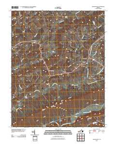 2010 Hansonville2010 Print · USGSCovers Hansonville, including Dickensonville, Zenobia, and other nearby areas
 - 2013 Map of Hansonville, 2013 Print
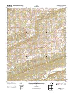 2013 Hansonville2013 Print · USGSCovers Hansonville, including Dickensonville, Zenobia, and other nearby areas
 - 2016 Map of Hansonville, 2016 Print
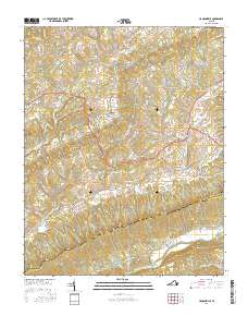 2016 Hansonville2016 Print · USGSCovers Hansonville, including Dickensonville, Zenobia, and other nearby areas
 - 2019 Map of Hansonville, 2019 Print
 2019 Hansonville2019 Print · USGSCovers Hansonville, including Dickensonville, Zenobia, and other nearby areas
 - 2022 Map of Hansonville, 2022 Print
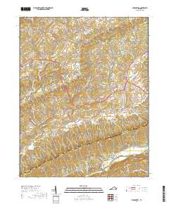
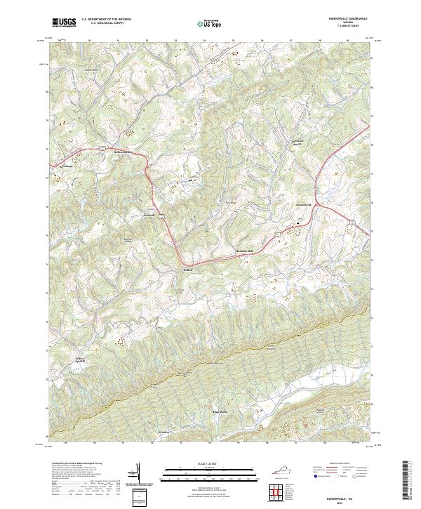 2022 Hansonville2022 Print · USGSSouthwest Virginia's ridge-and-valley landscape is documented here in the early twenty-first century, showing a network of historic gaps and river settlements. Genealogists can locate family landmarks like Davis Cem, Hawkins Mill, and the historic Courthouse at Dickensonville.
End of results
Showing maps 1-16 of 16
Top cities near Hansonville
- Abingdon historical maps
- Lebanon historical maps
- Castlewood historical maps
- St. Paul historical maps
- Saint Paul historical maps
- Honaker historical maps
See more
Frequently asked questions
- What are the different types of historical maps available for Hansonville?
- What is the oldest map of Hansonville?
- Where can I purchase historical maps of Hansonville for my home or office?
- Where can I download high-res historical maps of Hansonville?
- Are there historical topographic maps available for Hansonville?
- Is there historical aerial imagery available for Hansonville?
- Where are historical maps of Hansonville sourced from?