1930s Maps of Nickelsville, Virginia
Explore 5 historic maps of Nickelsville from the 1930s. These maps offer a rare glimpse into what life looked like during the 1930s — showing old roads, neighborhoods, homes, and landmarks that have changed or disappeared over time.
Whether you're researching your family's past, planning a metal detecting trip, or studying how Nickelsville's landscape evolved across the 1930s, these high-resolution maps are a powerful tool for exploring the history of this region.
- Focus on a specific era: All maps on this page are from the 1930s, giving you a focused view of this time period.
- See what’s changed: Compare century-old streets, trails, and buildings to today's modern landscape using overlays and satellite layers.
- Research with precision: Use these maps for genealogy, historical research, land use analysis, or educational projects.
- View, download, or print: Maps are fully viewable online in high resolution, and can be downloaded or printed for your own records.
Start exploring Nickelsville's history through authentic maps from the 1930s. This is your window into the past.
Nickelsville, VA maps
(5)- 1935 Map of Hilton
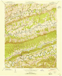
 1935 Hilton1935 Print · USGSScott County in the mid-thirties reveals a landscape of high ridges and fertile river valleys at the foot of Clinch Mountain. Genealogists and historians can trace old community hubs like Mace Springs P O and Dortons Fort, along with numerous rural schools and mills.
 - 1935 Map of Mages
 1935 Mages1935 Print · USGSThe Tennessee-Virginia borderlands appear here in the mid-1930s, showing a landscape of ridge-and-valley settlements and rural crossroads. Researchers can locate numerous family-centered sites including Pyles Cem, St Joseph Ch, and Mill Point.
 - 1935 Map of Dungannon
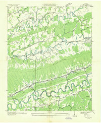
 1935 Dungannon1935 Print · USGSSouthwest Virginia's river valleys and ridgelines are documented here during the mid-1930s, showing the early infrastructure of the Clinch River corridor. Genealogists can trace family footprints through numerous rural schools and churches like New Bethel Sch, Wells Chapel, and the settlement at Nickelsville.
 - 1938 Map of Hilton, 1954 Print
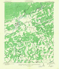
 1938 Hilton1954 Print · USGSScott County settlement patterns follow the winding waters of Copper Creek and the North Fork Holston River in the late thirties. Genealogists can trace early landmarks like Dorton Fort, McConnell Mill, and Francisco Cem.4 unique versions available
 - 1939 Map of Hilton
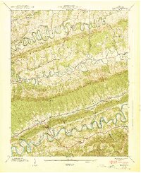 1939 Hilton1939 Print · USGSBefore the interstate era, this part of Scott County was a world of winding ridge-top roads and river mills. Genealogists can trace family landmarks like Francisco Cem, Dorton Fort, and old country schools from Snowflake to Maces Spring.2 unique versions available
End of results
Showing maps 1-5 of 5
Top cities near Nickelsville
- Kingsport historical maps
- Bristol historical maps
- Bloomingdale historical maps
- Norton historical maps
- Blountville historical maps
- Wise historical maps
See more
Frequently asked questions
- What are the different types of historical maps available for Nickelsville?
- What is the oldest map of Nickelsville?
- Where can I purchase historical maps of Nickelsville for my home or office?
- Where can I download high-res historical maps of Nickelsville?
- Are there historical topographic maps available for Nickelsville?
- Is there historical aerial imagery available for Nickelsville?
- Where are historical maps of Nickelsville sourced from?