1990s Maps of Dilbeck, Virginia
Explore 1 historic maps of Dilbeck from the 1990s. These maps offer a rare glimpse into what life looked like during the 1990s — showing old roads, neighborhoods, homes, and landmarks that have changed or disappeared over time.
Whether you're researching your family's past, planning a metal detecting trip, or studying how Dilbeck's landscape evolved across the 1990s, these high-resolution maps are a powerful tool for exploring the history of this region.
- Focus on a specific era: All maps on this page are from the 1990s, giving you a focused view of this time period.
- See what’s changed: Compare century-old streets, trails, and buildings to today's modern landscape using overlays and satellite layers.
- Research with precision: Use these maps for genealogy, historical research, land use analysis, or educational projects.
- View, download, or print: Maps are fully viewable online in high resolution, and can be downloaded or printed for your own records.
Start exploring Dilbeck's history through authentic maps from the 1990s. This is your window into the past.
Dilbeck, VA maps
(1)- 1994 Map of Strasburg, 1997 Print
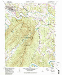 1994 Strasburg1997 Print · USGSThe Shenandoah Valley remains a vital rail and river corridor in the 1990s as the mountains frame a landscape of legacy and leisure. Trace the intersection of the Southern railroad at Strasburg, find old rural landmarks like Bennett Chapel, or explore the complex terrain of the Elizabeth Furnace Recreational Area.
End of results
Showing maps 1-1 of 1
Top cities near Dilbeck
- Front Royal historical maps
- Strasburg historical maps
- Woodstock historical maps
- Luray historical maps
- Stephens City historical maps
- Middletown historical maps
See more
Frequently asked questions
- What are the different types of historical maps available for Dilbeck?
- What is the oldest map of Dilbeck?
- Where can I purchase historical maps of Dilbeck for my home or office?
- Where can I download high-res historical maps of Dilbeck?
- Are there historical topographic maps available for Dilbeck?
- Is there historical aerial imagery available for Dilbeck?
- Where are historical maps of Dilbeck sourced from?