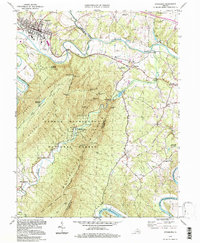
1994 Map of Strasburg
USGS Topo · Published 1997About this map
Strasburg serves as a critical junction for the Norfolk and Western and Southern railroads, situated along a sharp bend of the North Fork Shenandoah River. The landscape is dominated by the massive ridge of Massanutten Mountain, which creates a natural barrier between the main valley and the winding course of Passage Creek. Within this narrow corridor, the Elizabeth Furnace Recreational Area and the George Washington National Forest preserve the region's industrial and natural heritage, featuring an amphitheater, campground, and several scenic overlooks like Signal Knob. To the east, smaller rural communities such as Waterlick and Buckton are connected by the rail lines, while the Front Royal Warren County Airport sits near the eastern edge. Local history is documented through the locations of River View Cem, Bennett Chapel, and the Otterburn Sch, marking the persistence of rural life in the valley.
Find a feature on this map
62 named features on this map. Tap any name to fly to it.
Don’t see what you’re looking for? This feature index may not catch every label — zoom into the map to look around manually.
Map Details
Editions of this 1994 Strasburg Map
This is the sole edition of this map. No revisions or reprints were ever made.
Other maps of this area

1893 · Luray
USGS Topo · 1:125,000

1894 · Winchester
USGS Topo · 1:125,000

1905 · Luray
USGS Topo · 1:125,000

1923 · Middletown
USGS Topo · 1:62,500

1937 · Middletown
USGS Topo · 1:48,000

1938 · Winchester
USGS Topo · 1:48,000

1939 · Front Royal
USGS Topo · 1:48,000

1942 · Winchester
USGS Topo · 1:62,500

1943 · Middletown
USGS Topo · 1:62,500

1944 · Front Royal
USGS Topo · 1:62,500