
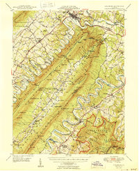
1950 Map of Strasburg
USGS Topo · Published 1950About this map
Strasburg anchors this mid-century survey of the northern Shenandoah Valley, where the dramatic oxbows of the North Fork Shenandoah River and South Fork Shenandoah River flank the massive ridge of Massanutten Mountain. The landscape is a corridor of historical transit, following the Valley Pike and Lee Highway through settlements like Maurertown, Toms Brook, and Fishers Hill. In the secluded Fort Valley between mountain ridges, small communities and landmarks like Seven Fountains, Saint Davids Church, and the Elizabeth Furnace Recreational Area suggest a way of life defined by the terrain's limestone geology, including Chalybeate Spring and numerous mountain gaps such as Woodstock Gap. Industrial and agricultural legacies are evident in the Southern Railway lines and family-named features like Goode Mill and Keller Cemetery, marking a period when these rural valley hubs remained the center of local commerce before modern expansion.
Find a feature on this map
115 named features on this map. Tap any name to fly to it.
Don’t see what you’re looking for? This feature index may not catch every label — zoom into the map to look around manually.
Map Details
Editions of this 1950 Strasburg Map
2 editions found
Other maps of this area

1891 · Romney
USGS Topo · 1:125,000

1892 · Woodstock
USGS Topo · 1:125,000

1893 · Luray
USGS Topo · 1:125,000

1894 · Winchester
USGS Topo · 1:125,000

1905 · Luray
USGS Topo · 1:125,000

1922 · Wardensville
USGS Topo · 1:62,500

1923 · Middletown
USGS Topo · 1:62,500

1923 · Edinburg
USGS Topo · 1:62,500

1924 · Wardensville
USGS Topo · 1:62,500

1929 · Stony Man
USGS Topo · 1:48,000