1900s (20th Century) Maps of Camp Corner, Virginia
Explore 6 historic maps of Camp Corner from the 1900s (20th Century). These maps offer a rare glimpse into what life looked like during the 1900s — showing old roads, neighborhoods, homes, and landmarks that have changed or disappeared over time.
Whether you're researching your family's past, planning a metal detecting trip, or studying how Camp Corner's landscape evolved across the 1900s, these high-resolution maps are a powerful tool for exploring the history of this region.
- Focus on a specific era: All maps on this page are from the 1900s, giving you a focused view of this time period.
- See what’s changed: Compare century-old streets, trails, and buildings to today's modern landscape using overlays and satellite layers.
- Research with precision: Use these maps for genealogy, historical research, land use analysis, or educational projects.
- View, download, or print: Maps are fully viewable online in high resolution, and can be downloaded or printed for your own records.
Start exploring Camp Corner's history through authentic maps from the 1900s. This is your window into the past.
Camp Corner, VA maps
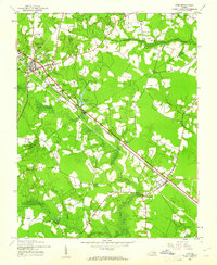
(6)- 1920 Map of Ivor
 1920 Ivor1920 Print · USGSCoastal plain life in Southampton and Isle of Wight counties is captured here just after the Great War, when rail and river travel still shaped the landscape. Genealogists can locate family landmarks like Tucker Swamp Church, Crumplers School, and Millfield Millpond.2 unique versions available
 - 1944 Map of Ivor, 1961 Print
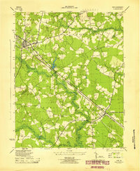
 1944 Ivor1961 Print · USGSCoastal Virginia during the mid-forties reveals a landscape of dense swamps and railroad-oriented towns. Genealogists and local historians can trace family roots through landmarks like Stephenson Cem, Mars Hill Ch, and the schools at Ivor.
 - 1945 Map of Ivor
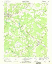
 1945 Ivor1945 Print · USGSCoastal Virginia's Tidewater region comes to life in the years following the war, centered on the railroad towns of Wakefield and Ivor. Genealogists and local historians can trace rural family life through meticulously marked sites like Stephenson Cem, Keitos Mill, and the Oak Grove School.
 - 1953 Map of Norfolk, 1954 Print
 1953 Norfolk1954 Print · USGSCoastal Virginia and northeastern North Carolina appear here during the post-war industrial boom, showing the critical rail-and-sea connections of Hampton Roads. Genealogists can trace family roots through rural landmarks like Gethsemane Ch, the Caledonia State Prison Farm, and the vast interior of the Dismal Swamp.4 unique versions available
 - 1968 Map of Ivor, 1970 Print
 1968 Ivor1970 Print · USGSCoastal Virginia's timber and rail country comes into focus in the late sixties as the Norfolk and Western line links rural crossroads. Genealogists and historians can trace family locations from Wakefield to Ivor, finding landmarks like Berlin-Ivor Sch and Spratley Cem.4 unique versions available
 - 1985 Map of Norfolk, 1986 Print
 1985 Norfolk1986 Print · USGSThe Tidewater region in the mid-eighties shows the dense urban expansion of the coastal cities alongside the preservation of the Great Dismal Swamp. Researchers can trace rural family-named crossroads and historic transit routes like the Seaboard Coast Line or find Somerton and Lake Drummond.3 unique versions available
End of results
Showing maps 1-6 of 6
Top cities near Camp Corner
- Franklin historical maps
- Windsor historical maps
- Waverly historical maps
- Courtland historical maps
- Wakefield historical maps
- Camptown historical maps
See more
Frequently asked questions
- What are the different types of historical maps available for Camp Corner?
- What is the oldest map of Camp Corner?
- Where can I purchase historical maps of Camp Corner for my home or office?
- Where can I download high-res historical maps of Camp Corner?
- Are there historical topographic maps available for Camp Corner?
- Is there historical aerial imagery available for Camp Corner?
- Where are historical maps of Camp Corner sourced from?