1990s Maps of Wilderness, Virginia
Explore 1 historic maps of Wilderness from the 1990s. These maps offer a rare glimpse into what life looked like during the 1990s — showing old roads, neighborhoods, homes, and landmarks that have changed or disappeared over time.
Whether you're researching your family's past, planning a metal detecting trip, or studying how Wilderness's landscape evolved across the 1990s, these high-resolution maps are a powerful tool for exploring the history of this region.
- Focus on a specific era: All maps on this page are from the 1990s, giving you a focused view of this time period.
- See what’s changed: Compare century-old streets, trails, and buildings to today's modern landscape using overlays and satellite layers.
- Research with precision: Use these maps for genealogy, historical research, land use analysis, or educational projects.
- View, download, or print: Maps are fully viewable online in high resolution, and can be downloaded or printed for your own records.
Start exploring Wilderness's history through authentic maps from the 1990s. This is your window into the past.
Wilderness, VA maps
(1)- 1994 Map of Chancellorsville, 1999 Print
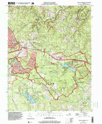 1994 Chancellorsville1999 Print · USGSSpotsylvania County in the mid-1990s reflects a landscape defined by Civil War memory and modern residential growth. Genealogists and historians can locate markers like the Jackson Monument and Hays Monument alongside settlements such as Wilderness Corner and Cookstown.
End of results
Showing maps 1-1 of 1
Top cities near Wilderness
- Lake of the Woods historical maps
- Spotsylvania Courthouse historical maps
- Remington historical maps
- Brandy Station historical maps
- Lake Wilderness historical maps
Frequently asked questions
- What are the different types of historical maps available for Wilderness?
- What is the oldest map of Wilderness?
- Where can I purchase historical maps of Wilderness for my home or office?
- Where can I download high-res historical maps of Wilderness?
- Are there historical topographic maps available for Wilderness?
- Is there historical aerial imagery available for Wilderness?
- Where are historical maps of Wilderness sourced from?