1900s (20th Century) Maps of Cavalier Park, Virginia Beach
Explore 10 historic maps of Cavalier Park from the 1900s (20th Century). These maps offer a rare glimpse into what life looked like during the 1900s — showing old roads, neighborhoods, homes, and landmarks that have changed or disappeared over time.
Whether you're researching your family's past, planning a metal detecting trip, or studying how Cavalier Park's landscape evolved across the 1900s, these high-resolution maps are a powerful tool for exploring the history of this region.
- Focus on a specific era: All maps on this page are from the 1900s, giving you a focused view of this time period.
- See what’s changed: Compare century-old streets, trails, and buildings to today's modern landscape using overlays and satellite layers.
- Research with precision: Use these maps for genealogy, historical research, land use analysis, or educational projects.
- View, download, or print: Maps are fully viewable online in high resolution, and can be downloaded or printed for your own records.
Start exploring Cavalier Park's history through authentic maps from the 1900s. This is your window into the past.
Cavalier Park, Virginia Beach maps
(10)- 1907 Map of Norfolk
 1907 Norfolk1907 Print · USGSCoastal Virginia is mapped here at the dawn of the twentieth century, during the bustle of the great Jamestown Exposition. Researchers can trace the early rail-and-canal economy through the Albemarle and Chesapeake Canal, the Navy Yard, and historic outposts like the Cape Henry Light.
 - 1946 Map of Eastville, 1971 Print
 1946 Eastville1971 Print · USGSCoastal Virginia and the Outer Banks are captured here during a period of expanding naval and aerospace presence. Researchers can trace the path of the Penn Central railroad through Chincoteague and Modest Town, or locate landmarks like the Wright Brothers National Memorial.
 - 1946 Map of Currituck Sound, 1980 Print
 1946 Currituck Sound1980 Print · USGSThe Virginia and North Carolina coastline appears in detail during the mid-twentieth century as a network of maritime villages and military outposts. Genealogists and local historians can trace family locations from Virginia Beach south to Kitty Hawk, including landmarks like the Currituck Beach Lighthouse and the Wright Brothers National Memorial.
 - 1948 Map of Virginia Beach
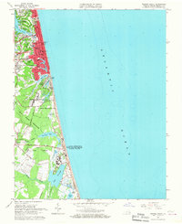
 1948 Virginia Beach1948 Print · USGSCoastal Virginia in the late 1940s is defined by a landscape of military installations and early resort development along the Atlantic. Researchers can trace the Norfolk Southern rail line to Casino Station, locate the grounds of Camp Pendleton, and explore old settlements like Seatack and Atwoodtown.
 - 1955 Map of Virginia Beach, 1958 Print
 1955 Virginia Beach1958 Print · USGSCoastal Virginia in the mid-fifties is seen here as a mix of growing beach resorts and significant Cold War-era military training grounds. Researchers can trace the early layout of Virginia Beach and find local landmarks like Mt Olive Ch, Seatack Sch, and the Coast Guard Station.
 - 1961 Map of Eastville
 1961 Eastville1961 Print · USGSThe Eastern Shore and Outer Banks are captured here in the mid-twentieth century, showing a maritime landscape of lighthouses, rail-linked towns, and naval outposts. Researchers can trace the Pennsylvania Railroad through Parksley or locate historical sites like Chincoteague Field Naval Auxiliary Air Station and Tangier Island.
 - 1965 Map of Virginia Beach, 1967 Print
 1965 Virginia Beach1967 Print · USGSCoastal Virginia in the mid-sixties reveals a landscape of expanding beach communities and critical Cold War-era naval installations. Researchers can trace the legacy of the Norfolk Southern rail line or locate landmarks like the Coast Guard Station Radio Tower and Seatack.8 unique versions available
 - 1966 Map of Eastville
 1966 Eastville1966 Print · USGSThe Delmarva Peninsula and Outer Banks appear in the mid-sixties, showing a landscape of maritime trade, military outposts, and fishing villages. Researchers can trace the lines of the Norfolk & Southern through Exmore and Parksley or locate historical sites like Fort John Custis and the Janes Island Lighthouse.
 - 1985 Map of Virginia Beach
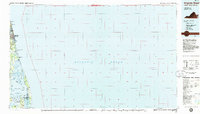 1985 Virginia Beach1985 Print · USGSThe Virginia and North Carolina coastline in the mid-eighties shows a landscape of strategic naval bases and expansive wildlife refuges. Trace the development of Sandbridge Beach, locate inland points like Dawley Corners, and explore the marshes of Back Bay.
 - 1990 Map of Virginia Beach
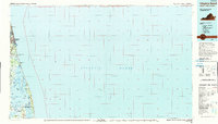 1990 Virginia Beach1990 Print · USGSThe Virginia and North Carolina coastline in the early nineties showcases a landscape of naval installations and protected wildlife corridors. Genealogists and historians can trace the development of Virginia Beach alongside older communities like Dawley Corners and Sigma.
End of results
Showing maps 1-10 of 10
Frequently asked questions
- What are the different types of historical maps available for Cavalier Park?
- What is the oldest map of Cavalier Park?
- Where can I purchase historical maps of Cavalier Park for my home or office?
- Where can I download high-res historical maps of Cavalier Park?
- Are there historical topographic maps available for Cavalier Park?
- Is there historical aerial imagery available for Cavalier Park?
- Where are historical maps of Cavalier Park sourced from?