Old Maps of Creeds, Virginia Beach for Academic Research
Study the evolution of Creeds with 11 high-resolution historic maps. Whether you're teaching, researching, or modeling changes in land use, these maps provide essential visual documentation of urban, environmental, and geographic change.
- Analyze long-term change: Track patterns in development, transportation, and natural features.
- Ideal for environmental or urban studies: Support academic projects with primary historical map data.
- Use in the classroom or lab: Educators and researchers rely on these maps to bring historical context to life.
These maps are a powerful tool for teaching, research, and visualizing how Creeds has changed over the decades.
Creeds, Virginia Beach maps
(11)- 1939 Map of Moyock, 1959 Print
 1939 Moyock1959 Print · USGSThe Virginia and North Carolina borderlands come to life in this pre-war survey of the tidewater region, where the Intracoastal Waterway meets the coastal swamps. Researchers can trace family roots through numerous landmarks like Moyock Cem, Pungo Ferry, and the Willow Grove Sch.
 - 1946 Map of Moyock
 1946 Moyock1946 Print · USGSThe Virginia and North Carolina borderlands come alive in the mid-1940s, showing a landscape of rail-connected crossroads and tidal waterways. Genealogists can locate family landmarks like Moyock Cem, St Brides, and the Willow Grove Sch.2 unique versions available
 - 1953 Map of Norfolk, 1954 Print
 1953 Norfolk1954 Print · USGSCoastal Virginia and northeastern North Carolina appear here during the post-war industrial boom, showing the critical rail-and-sea connections of Hampton Roads. Genealogists can trace family roots through rural landmarks like Gethsemane Ch, the Caledonia State Prison Farm, and the vast interior of the Dismal Swamp.4 unique versions available
 - 1954 Map of Creeds, 1956 Print
 1954 Creeds1956 Print · USGSCoastal Virginia and North Carolina are mapped here in the mid-1950s, showing the intersection of river life and rural farming. Researchers can trace family roots at Kala Ch, find the location of the Creeds Sch, or locate the Creeds Field (Abandoned).4 unique versions available
 - 1977 Map of Creeds, 1979 Print
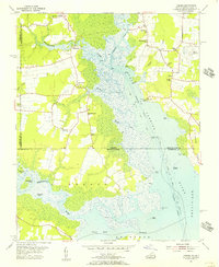
 1977 Creeds1979 Print · USGSThe Virginia and North Carolina borderlands come to life in this late 1970s aerial survey. Researchers can trace the layout of coastal settlements like Creeds and Munden alongside the marshes of the North Landing River.
 - 1985 Map of Norfolk, 1986 Print
 1985 Norfolk1986 Print · USGSThe Tidewater region in the mid-eighties shows the dense urban expansion of the coastal cities alongside the preservation of the Great Dismal Swamp. Researchers can trace rural family-named crossroads and historic transit routes like the Seaboard Coast Line or find Somerton and Lake Drummond.3 unique versions available
 - 2011 Map of Creeds, 2011 Print
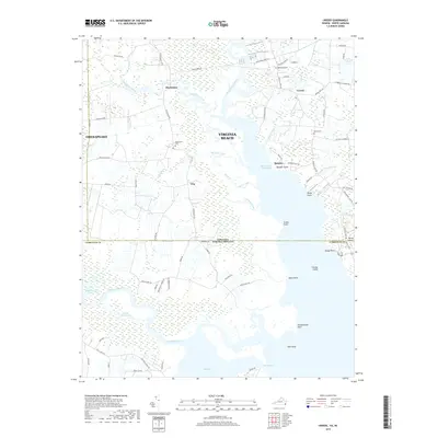
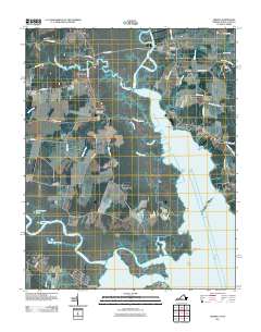 2011 Creeds2011 Print · USGSCovers Creeds, including Pungo Ferry, Vine, and other nearby areas
 - 2013 Map of Creeds, 2013 Print
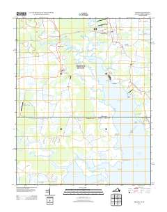 2013 Creeds2013 Print · USGSCovers Creeds, including Pungo Ferry, Vine, and other nearby areas
 - 2016 Map of Creeds, 2016 Print
 2016 Creeds2016 Print · USGSCovers Creeds, including Pungo Ferry, Vine, and other nearby areas
 - 2019 Map of Creeds, 2019 Print
 2019 Creeds2019 Print · USGSCovers Creeds, including Pungo Ferry, Vine, and other nearby areas
 - 2022 Map of Creeds, 2022 Print
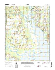
 2022 Creeds2022 Print · USGSCoastal Virginia and North Carolina meet in this recent survey of the tidal marshes and waterways south of Virginia Beach. Researchers can trace family sites at Oak Grove Cem or follow the Intracoastal Waterway past Munden and Faraby Island.
End of results
Showing maps 1-11 of 11
Frequently asked questions
- What are the different types of historical maps available for Creeds?
- What is the oldest map of Creeds?
- Where can I purchase historical maps of Creeds for my home or office?
- Where can I download high-res historical maps of Creeds?
- Are there historical topographic maps available for Creeds?
- Is there historical aerial imagery available for Creeds?
- Where are historical maps of Creeds sourced from?