1900s (20th Century) Maps of Pungo, Virginia Beach
Explore 6 historic maps of Pungo from the 1900s (20th Century). These maps offer a rare glimpse into what life looked like during the 1900s — showing old roads, neighborhoods, homes, and landmarks that have changed or disappeared over time.
Whether you're researching your family's past, planning a metal detecting trip, or studying how Pungo's landscape evolved across the 1900s, these high-resolution maps are a powerful tool for exploring the history of this region.
- Focus on a specific era: All maps on this page are from the 1900s, giving you a focused view of this time period.
- See what’s changed: Compare century-old streets, trails, and buildings to today's modern landscape using overlays and satellite layers.
- Research with precision: Use these maps for genealogy, historical research, land use analysis, or educational projects.
- View, download, or print: Maps are fully viewable online in high resolution, and can be downloaded or printed for your own records.
Start exploring Pungo's history through authentic maps from the 1900s. This is your window into the past.
Pungo, Virginia Beach maps
(6)- 1907 Map of Norfolk
 1907 Norfolk1907 Print · USGSCoastal Virginia is mapped here at the dawn of the twentieth century, during the bustle of the great Jamestown Exposition. Researchers can trace the early rail-and-canal economy through the Albemarle and Chesapeake Canal, the Navy Yard, and historic outposts like the Cape Henry Light.
 - 1939 Map of Moyock, 1959 Print
 1939 Moyock1959 Print · USGSThe Virginia and North Carolina borderlands come to life in this pre-war survey of the tidewater region, where the Intracoastal Waterway meets the coastal swamps. Researchers can trace family roots through numerous landmarks like Moyock Cem, Pungo Ferry, and the Willow Grove Sch.
 - 1946 Map of Moyock
 1946 Moyock1946 Print · USGSThe Virginia and North Carolina borderlands come alive in the mid-1940s, showing a landscape of rail-connected crossroads and tidal waterways. Genealogists can locate family landmarks like Moyock Cem, St Brides, and the Willow Grove Sch.2 unique versions available
 - 1953 Map of Norfolk, 1954 Print
 1953 Norfolk1954 Print · USGSCoastal Virginia and northeastern North Carolina appear here during the post-war industrial boom, showing the critical rail-and-sea connections of Hampton Roads. Genealogists can trace family roots through rural landmarks like Gethsemane Ch, the Caledonia State Prison Farm, and the vast interior of the Dismal Swamp.4 unique versions available
 - 1954 Map of Pleasant Ridge, 1956 Print
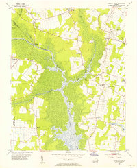 1954 Pleasant Ridge1956 Print · USGSCoastal Virginia in the mid-fifties is captured here during a period of rural stability and maritime importance. Genealogists and local historians can trace family-named landmarks and old post offices such as Back Bay (Backbay P O), Dawley Corners, and Camels Chapel.7 unique versions available
 - 1985 Map of Norfolk, 1986 Print
 1985 Norfolk1986 Print · USGSThe Tidewater region in the mid-eighties shows the dense urban expansion of the coastal cities alongside the preservation of the Great Dismal Swamp. Researchers can trace rural family-named crossroads and historic transit routes like the Seaboard Coast Line or find Somerton and Lake Drummond.3 unique versions available
End of results
Showing maps 1-6 of 6
Frequently asked questions
- What are the different types of historical maps available for Pungo?
- What is the oldest map of Pungo?
- Where can I purchase historical maps of Pungo for my home or office?
- Where can I download high-res historical maps of Pungo?
- Are there historical topographic maps available for Pungo?
- Is there historical aerial imagery available for Pungo?
- Where are historical maps of Pungo sourced from?