1960s Maps of Eagle Furnace, Virginia
Explore 2 historic maps of Eagle Furnace from the 1960s. These maps offer a rare glimpse into what life looked like during the 1960s — showing old roads, neighborhoods, homes, and landmarks that have changed or disappeared over time.
Whether you're researching your family's past, planning a metal detecting trip, or studying how Eagle Furnace's landscape evolved across the 1960s, these high-resolution maps are a powerful tool for exploring the history of this region.
- Focus on a specific era: All maps on this page are from the 1960s, giving you a focused view of this time period.
- See what’s changed: Compare century-old streets, trails, and buildings to today's modern landscape using overlays and satellite layers.
- Research with precision: Use these maps for genealogy, historical research, land use analysis, or educational projects.
- View, download, or print: Maps are fully viewable online in high resolution, and can be downloaded or printed for your own records.
Start exploring Eagle Furnace's history through authentic maps from the 1960s. This is your window into the past.
Eagle Furnace, VA maps
(2)- 1962 Map of Winston-Salem
 1962 Winston-Salem1962 Print · USGSThe North Carolina Piedmont meets the Virginia highlands in the early sixties, showing the rail corridors and mountain gaps of the southern Appalachians. Researchers can trace the Blue Ridge Parkway or locate family sites near Winston-Salem, Mount Airy, and Hanging Rock Mountain.
 - 1968 Map of Cripple Creek, 1971 Print
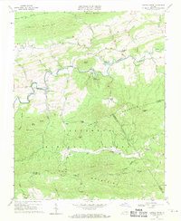 1968 Cripple Creek1971 Print · USGSCripple Creek and the northern ridges of the Jefferson National Forest are captured here in the late sixties as the region's industrial relics began to fade. Genealogists and historians can trace family sites at Davis Cem, old congregations like Bethany Ch, and industrial ruins at Eagle Furnace.2 unique versions available
End of results
Showing maps 1-2 of 2
Top cities near Eagle Furnace
- Wytheville historical maps
- Galax historical maps
- Rural Retreat historical maps
- Independence historical maps
- Fort Chiswell historical maps
- Max Meadows historical maps
See more
Frequently asked questions
- What are the different types of historical maps available for Eagle Furnace?
- What is the oldest map of Eagle Furnace?
- Where can I purchase historical maps of Eagle Furnace for my home or office?
- Where can I download high-res historical maps of Eagle Furnace?
- Are there historical topographic maps available for Eagle Furnace?
- Is there historical aerial imagery available for Eagle Furnace?
- Where are historical maps of Eagle Furnace sourced from?