1962 Map of Winston-Salem
USGS Topo · Published 1962About this map
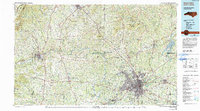
The Blue Ridge escarpment dominates this 1962 revision of the region, defining the transition between the rolling Piedmont of North Carolina and the high mountain plateaus of Virginia. In the southeast, the urban center of Winston-Salem serves as a major hub, connected by the Southern Ry and the Atlantic and Yadkin Ry to outlying towns like Rural Hall and Walnut Cove. The landscape transitions northward into the Sauratown Mountains, featuring the distinctive profile of Hanging Rock Mountain.
Find a feature on this map
79 named features on this map. Tap any name to fly to it.
Don’t see what you’re looking for? This feature index may not catch every label — zoom into the map to look around manually.
Map Details
Editions of this 1962 Winston-Salem Map
This is the sole edition of this map. No revisions or reprints were ever made.
Historical Maps of Greensboro Through Time
4 maps found