1970s Maps of West Richland, Washington
Explore 2 historic maps of West Richland from the 1970s. These maps offer a rare glimpse into what life looked like during the 1970s — showing old roads, neighborhoods, homes, and landmarks that have changed or disappeared over time.
Whether you're researching your family's past, planning a metal detecting trip, or studying how West Richland's landscape evolved across the 1970s, these high-resolution maps are a powerful tool for exploring the history of this region.
- Focus on a specific era: All maps on this page are from the 1970s, giving you a focused view of this time period.
- See what’s changed: Compare century-old streets, trails, and buildings to today's modern landscape using overlays and satellite layers.
- Research with precision: Use these maps for genealogy, historical research, land use analysis, or educational projects.
- View, download, or print: Maps are fully viewable online in high resolution, and can be downloaded or printed for your own records.
Start exploring West Richland's history through authentic maps from the 1970s. This is your window into the past.
West Richland, WA maps
(2)- 1974 Map of Benton City, 1977 Print
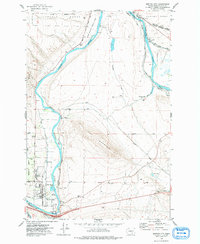 1974 Benton City1977 Print · USGSBenton City and Kiona sit at a vital river bend in the 1970s, where rail lines and irrigation canals meet the shadow of Red Mountain. Genealogists and local historians can trace the foundations of the community through Evergreen Cem, the Kiona-Benton City Sch, and the sprawling Hanford Works boundary.
 - 1978 Map of Richland
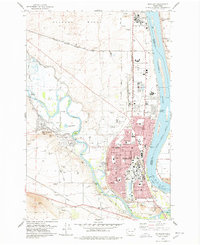 1978 Richland1978 Print · USGSRichland and West Richland are shown in the late seventies as the region functioned as a critical hub for energy and atomic research. Researchers can trace the industrial layout of the Hanford Works or locate local landmarks like the Westie Drive-in Theatre and Resthaven Cem.
End of results
Showing maps 1-2 of 2
Top cities near West Richland
Top neighborhoods of West Richland
Frequently asked questions
- What are the different types of historical maps available for West Richland?
- What is the oldest map of West Richland?
- Where can I purchase historical maps of West Richland for my home or office?
- Where can I download high-res historical maps of West Richland?
- Are there historical topographic maps available for West Richland?
- Is there historical aerial imagery available for West Richland?
- Where are historical maps of West Richland sourced from?