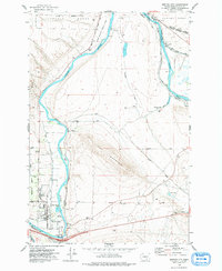
1974 Map of Benton City
USGS Topo · Published 1977About this map
Benton City and the neighboring settlement of Kiona occupy a strategic bend in the Yakima River during the mid-1970s, serving as a hub for both agricultural irrigation and regional transport. The landscape is defined by the massive rise of Red Mountain and the intricate network of water management systems, including the Kiona Canal, Columbia Canal, and Richland Canal, which transformed this arid terrain into productive land.
Find a feature on this map
38 named features on this map. Tap any name to fly to it.
Don’t see what you’re looking for? This feature index may not catch every label — zoom into the map to look around manually.
Map Details
Editions of this 1974 Benton City Map
This is the sole edition of this map. No revisions or reprints were ever made.
Other maps of this area

1915 · Prosser
USGS Topo · 1:125,000

1917 · Pasco
USGS Topo · 1:125,000

1917 · Prosser
USGS Topo · 1:125,000

1951 · Richland
USGS Topo · 1:62,500

1951 · Corral Canyon
USGS Topo · 1:62,500

1953 · Walla Walla
USGS Topo · 1:250,000

1958 · Walla Walla
USGS Topo · 1:250,000

1965 · Whitstran
USGS Topo · 1:62,500
1965 · Weber Canyon
USGS Topo · 1:24,000
1965 · Whitstran NE
USGS Topo · 1:24,000