
1915 Map of Prosser
USGS Topo · Published 1957About this map
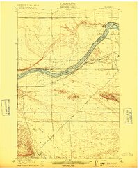
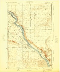
The Yakima River carves a fertile corridor through this 1915 survey, defining a landscape bounded by the Rattlesnake Hills to the north and the Horse Heaven Hills to the south. This era shows the early development of irrigation and transport in the region, with the Sunnyside Canal and Sunnyside Road supporting a growing network of agricultural settlements. The towns of Prosser, Grandview, and Mabton serve as hubs for the surrounding farmsteads, while the Northern Pacific and Union Pacific railroads provide the vital infrastructure for moving goods out of the valley.
Find a feature on this map
83 named features on this map. Tap any name to fly to it.
Don’t see what you’re looking for? This feature index may not catch every label — zoom into the map to look around manually.
Map Details
Editions of this 1915 Prosser Map
This is the sole edition of this map. No revisions or reprints were ever made.
Other maps of this area

1906 · Blalock Island
USGS Topo · 1:125,000

1908 · Blalock Island
USGS Topo · 1:125,000

1908 · Umatilla
USGS Topo · 1:125,000

1910 · Zillah
USGS Topo · 1:125,000

1916 · Arlington
USGS Topo · 1:125,000
1916 · Coyote Rapids
USGS Topo · 1:62,500

1917 · Pasco
USGS Topo · 1:125,000

1917 · Priest Rapids
USGS Topo · 1:62,500

1917 · Prosser
USGS Topo · 1:125,000
1924 · Hanford
USGS Topo · 1:62,500