
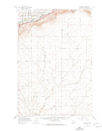
1965 Map of Whitstran
USGS Topo · Published 1966About this map
The Yakima River flows through the northern reaches of this mid-1960s survey, marking the fertile transition between the Yakima Valley and the rising slopes of the Horse Heaven Hills. The settlement of Whitstran and the eastern edge of Prosser serve as the primary hubs, connected by the historic route of the Old Inland Empire Highway and the Northern Pacific railroad. The landscape is defined by its agricultural infrastructure, featuring an intricate network of irrigation systems including the Pacific Canal, several aqueducts, and a large siphon.
Find a feature on this map
56 named features on this map. Tap any name to fly to it.
Don’t see what you’re looking for? This feature index may not catch every label — zoom into the map to look around manually.
Map Details
Editions of this 1965 Whitstran Map
2 editions found
Other maps of this area

1906 · Blalock Island
USGS Topo · 1:125,000

1908 · Blalock Island
USGS Topo · 1:125,000

1908 · Umatilla
USGS Topo · 1:125,000

1915 · Prosser
USGS Topo · 1:125,000

1917 · Pasco
USGS Topo · 1:125,000

1917 · Prosser
USGS Topo · 1:125,000

1950 · Grandview
USGS Topo · 1:62,500

1951 · Grandview
USGS Topo · 1:62,500

1951 · Richland
USGS Topo · 1:62,500

1951 · Corral Canyon
USGS Topo · 1:62,500