
1950 Map of Grandview
USGS Topo · Published 1964About this map
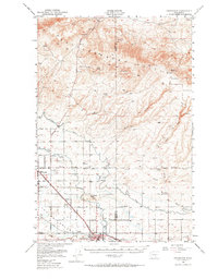
The Yakima Valley floor reveals a landscape defined by intensive irrigation and rail infrastructure at mid-century, where the Roza Canal and Sunnyside Canal contour through the basin. Large settlements like Grandview and Sunnyside anchor the agricultural economy, supported by smaller railway stops and locales such as Lichty and Forsell. To the north, the terrain rises sharply into the Rattlesnake Hills, a starkly different environment marked by remote springs such as Butler Spring and Maiden Spr. The transition from the high desert of Black Rock Canyon to the cultivated valley floor is punctuated by specialized land uses, including the Sunnyside Municipal Airport and the Lower Valley Country Club. This survey, based on field work through 1950, documents the area's development before major interstate expansions altered the local corridors like Hanford Road and Sunnyside Road.
Find a feature on this map
36 named features on this map. Tap any name to fly to it.
Don’t see what you’re looking for? This feature index may not catch every label — zoom into the map to look around manually.
Map Details
Editions of this 1950 Grandview Map
2 editions found
Other maps of this area

1910 · Zillah
USGS Topo · 1:125,000

1915 · Prosser
USGS Topo · 1:125,000

1916 · Coyote Rapids
USGS Topo · 1:62,500

1917 · Priest Rapids
USGS Topo · 1:62,500

1917 · Prosser
USGS Topo · 1:125,000

1936 · Hog Ranch Buttes
USGS Topo · 1:48,000

1941 · Black Rock Spring
USGS Topo · 1:62,500

1948 · Cairn Hope Peak
USGS Topo · 1:24,000

1948 · Emerson Nipple
USGS Topo · 1:24,000

1950 · Yakima
USGS Topo · 1:250,000