
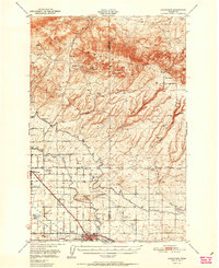
1951 Map of Grandview
USGS Topo · Published 1951About this map
Irrigated valleys and the rising Rattlesnake Hills define the landscape of the Yakima Valley at mid-century. The intricate engineering of the Sunnyside Canal and the Roza Canal dominates the lowlands, supporting the intensive agriculture that drove the development of Grandview and Sunnyside. In the southern portion of the sheet, the transportation network is anchored by the competing lines of the Northern Pacific and Union Pacific railroads, which parallel the canal systems through the valley floor.
Find a feature on this map
32 named features on this map. Tap any name to fly to it.
Don’t see what you’re looking for? This feature index may not catch every label — zoom into the map to look around manually.
Map Details
Editions of this 1951 Grandview Map
2 editions found
Other maps of this area

1910 · Zillah
USGS Topo · 1:125,000

1915 · Prosser
USGS Topo · 1:125,000

1916 · Coyote Rapids
USGS Topo · 1:62,500

1917 · Priest Rapids
USGS Topo · 1:62,500

1917 · Prosser
USGS Topo · 1:125,000

1936 · Hog Ranch Buttes
USGS Topo · 1:48,000

1941 · Black Rock Spring
USGS Topo · 1:62,500

1948 · Cairn Hope Peak
USGS Topo · 1:24,000

1948 · Emerson Nipple
USGS Topo · 1:24,000

1950 · Yakima
USGS Topo · 1:250,000