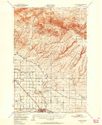
1951 Map of Grandview
USGS Topo · Published 1951About this map
The Rattlesnake Hills dominate the northern horizon of this 1951 Yakima Valley survey, providing a stark contrast to the burgeoning agricultural landscape to the south. Central to this development is the Sunnyside Canal and the Roza Road, which facilitate the irrigation and transport essential to the local economy. The towns of Sunnyside and Grandview serve as primary hubs, supported by smaller settlements and rail stops like Lichty and Forsell. The presence of both the Northern Pacific and Union Pacific railroads underscores the importance of the region as a shipping corridor for the valley's produce. Notable landmarks such as the Sunnyside Municipal Airport and Lower Valley Country Club reflect the mid-century growth and social infrastructure of the area, while family-held land like the Bennett Ranch and Anderson Ranch point to the deep-rooted ranching history in the shadow of Grandview Butte.
Find a feature on this map
27 named features on this map. Tap any name to fly to it.
Don’t see what you’re looking for? This feature index may not catch every label — zoom into the map to look around manually.
Map Details
Editions of this 1951 Grandview Map
2 editions found

Other maps of this area

1910 · Zillah
USGS Topo · 1:125,000

1915 · Prosser
USGS Topo · 1:125,000

1916 · Coyote Rapids
USGS Topo · 1:62,500

1917 · Priest Rapids
USGS Topo · 1:62,500

1917 · Prosser
USGS Topo · 1:125,000

1936 · Hog Ranch Buttes
USGS Topo · 1:48,000

1941 · Black Rock Spring
USGS Topo · 1:62,500

1948 · Cairn Hope Peak
USGS Topo · 1:24,000

1948 · Emerson Nipple
USGS Topo · 1:24,000

1950 · Yakima
USGS Topo · 1:250,000