Old Maps of Lucerne, Washington
Explore 10 old maps of Lucerne, spanning from 1902 to today. These high-resolution historic maps reveal how streets, neighborhoods, landmarks, and natural features evolved over time — perfect for genealogy, metal detecting, research, and local history exploration.
What you can do with these maps:
- See how Lucerne changed over time: Compare historical maps to modern-day views to trace roads, homesites, rail lines & more.
- View detailed metadata: Each map includes creators, publishers, year, scale, and archive source.
- Overlay maps with satellite & LiDAR: Visualize the past alongside modern tools to explore terrain & human change.
- Trusted historical sources: Maps sourced from the USGS, Library of Congress, and other archives.
- Access maps your way: View online, download high-res files, or order prints for personal or research use.
Start exploring old maps of Lucerne to uncover forgotten places, hidden landmarks, and the deep history beneath your feet.
Lucerne, WA maps
(10)- 1902 Map of Stehekin, 1955 Print
 1902 Stehekin1955 Print · USGSLake Chelan and the North Cascades are captured here at the dawn of the twentieth century, during a period of remote mountain development. Genealogists and historians can trace early settlements at Stehekin, Lucerne, and Gilbert, along with the route of the Holden Railroad.2 unique versions available
 - 1904 Map of Stehekin
 1904 Stehekin1904 Print · USGSThe northern reaches of Lake Chelan are captured here at the turn of the century, showing a wilderness being shaped by early mountain outposts and mining. Genealogists and researchers can trace remote sites like Gilbert and Holden, or the unique path of the Holden Railroad.5 unique versions available
 - 1944 Map of Lucerne, 1966 Print
 1944 Lucerne1966 Print · USGSLake Chelan's western shore remained accessible only by water in the 1940s, anchoring a landscape of isolated mountain outposts and high-elevation forestry. You can trace the Steamer Route to Lucerne, find the Edit Mine, and locate the old Cottonwood Guard Sta.3 unique versions available
 - 1949 Map of Lucerne
 1949 Lucerne1949 Print · USGSLake Chelan and the surrounding wilderness are captured here in the late 1940s, highlighting a landscape defined by mountain peaks and lake-bound transit. Map collectors can trace the Steamer Route to Chelan and find historical sites like Lucerne and the Edit Mine.2 unique versions available
 - 1955 Map of Concrete, 1967 Print
 1955 Concrete1967 Print · USGSThe North Cascades in the mid-fifties reveal a landscape of deep glacier-fed lakes and riverside timber towns. You can trace the Great Northern rail lines through Granite Falls or locate remote outposts like Stehekin and Marblemount along the Skagit and Chelan waters.
 - 1958 Map of Concrete
 1958 Concrete1958 Print · USGSThe North Cascades and Skagit Valley are captured here in the late fifties, showing a landscape defined by glacier-carved peaks and river-bottom settlements. Genealogists and historians can locate remote mining sites like Holden Mine and mountain outposts such as Stehekin, Marblemount, and Mazama.2 unique versions available
 - 1962 Map of Concrete
 1962 Concrete1962 Print · USGSThe Northern Cascades in the early sixties reveal a landscape of high alpine peaks and deep river valleys before the modern park era. Genealogists and historians can trace rail-and-river towns like Concrete, Darrington, and Stehekin, alongside industry at the Holden Mine.
 - 1988 Map of Lucerne
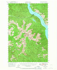
 1988 Lucerne1988 Print · USGSLake Chelan's western shore in the late eighties remained a wilderness frontier defined by ferry access and high-altitude ridges. Researchers can trace remote sites like Lucerne and Moore, alongside landmarks like Domke Falls and Bearcat Ridge.
 - 2004 Map of Lucerne, 2008 Print
 2004 Lucerne2008 Print · USGSLake Chelan's remote western shores and the settlement of Lucerne are documented here as they appeared in the early 2000s. Researchers can trace the water-access-only landscape including Moore Point (Site), the local Hatchery, and Refrigerator Harbor.
 - 2023 Map of Lucerne, 2023 Print
 2023 Lucerne2023 Print · USGSThe northern reaches of Lake Chelan are mapped here in the modern era, showing the remote landings and wilderness trails only reachable by water. Researchers can trace the Lake Chelan Ferry route to Lucerne or follow the Domke Mountain Lookout Trl above Domke Falls.
End of results
Showing maps 1-10 of 10
Frequently asked questions
- What are the different types of historical maps available for Lucerne?
- What is the oldest map of Lucerne?
- Where can I purchase historical maps of Lucerne for my home or office?
- Where can I download high-res historical maps of Lucerne?
- Are there historical topographic maps available for Lucerne?
- Is there historical aerial imagery available for Lucerne?
- Where are historical maps of Lucerne sourced from?