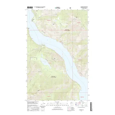
2017 Map of Lucerne
USGS Topo · Published 2017About this map
Lake Chelan dominates this section of the Cascade Range, where the remote settlement of Lucerne sits at the mouth of Railroad Cr. The map details the steep topography of the Wenatchee National Forest, transitioning from the shoreline at Moore Point to the high elevations of Round Mtn and Bearcat Ridge. A network of trails and access points, such as the Domke Lake NRT and Lakeshore (Chelan) route, connect the lakefront to interior features like Domke Lake and the Domke Mountain Lookout. The landscape is defined by its drainage systems, including Fish Cr and Bear Cr, which carve through the forest toward the lake. This survey illustrates the preserved nature of the Lower Railroad Cr Wilderness and the Emerald Park area, showcasing a region where transport remains primarily dependent on the water and established forest trails.
Find a feature on this map
43 named features on this map. Tap any name to fly to it.
Don’t see what you’re looking for? This feature index may not catch every label — zoom into the map to look around manually.
Map Details
Editions of this 2017 Lucerne Map
This is the sole edition of this map. No revisions or reprints were ever made.
Other maps of this area

1899 · Methow
USGS Topo · 1:125,000

1901 · Methow
USGS Topo · 1:125,000

1902 · Stehekin
USGS Topo · 1:125,000

1904 · Stehekin
USGS Topo · 1:125,000

1944 · Lucerne
USGS Topo · 1:62,500

1949 · Lucerne
USGS Topo · 1:62,500

1955 · Concrete
USGS Topo · 1:250,000

1958 · Concrete
USGS Topo · 1:250,000

1962 · Concrete
USGS Topo · 1:250,000
1968 · Big Goat Mtn
USGS Topo · 1:24,000