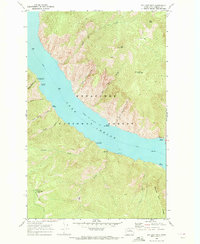
1968 Map of Big Goat Mtn
USGS Topo · Published 1972About this map
Lake Chelan dominates this landscape, its waters filling a deep glacial trough within the Wenatchee National Forest. This 1968 field-checked map records the lake at its normal pool elevation of 1098 feet, showing the ferry route that remains the primary lifeline for this roadless mountain terrain. The eastern shore is defined by the steep rises of Big Goat Mtn and Little Goat Mtn, while the southwestern banks are notched by small havens like Graham Harbor and Deep Harbor.
Find a feature on this map
35 named features on this map. Tap any name to fly to it.
Don’t see what you’re looking for? This feature index may not catch every label — zoom into the map to look around manually.
Map Details
Editions of this 1968 Big Goat Mtn Map
3 editions found
Other maps of this area

1899 · Methow
USGS Topo · 1:125,000

1901 · Chelan
USGS Topo · 1:125,000

1901 · Methow
USGS Topo · 1:125,000

1901 · Chiwaukum
USGS Topo · 1:125,000

1902 · Stehekin
USGS Topo · 1:125,000

1904 · Stehekin
USGS Topo · 1:125,000

1904 · Chiwaukum
USGS Topo · 1:125,000

1944 · Lucerne
USGS Topo · 1:62,500

1949 · Lucerne
USGS Topo · 1:62,500

1955 · Concrete
USGS Topo · 1:250,000