
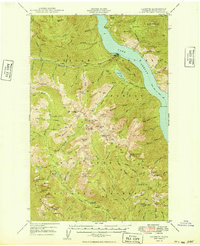
1949 Map of Lucerne
USGS Topo · Published 1949About this map
Lake Chelan dominates this 1940s landscape, serving as the primary corridor for transportation through the Chelan National Forest. The settlement of Lucerne sits at the junction of the lake and Railroad Creek, acting as a gateway for interior resource extraction such as the Edit Mine near the Riddle Peaks. Accessibility in this high-altitude region relied heavily on water and trail networks, indicated by the Steamer Route to Chelan and the Emerald Park Trail.
Find a feature on this map
95 named features on this map. Tap any name to fly to it.
Don’t see what you’re looking for? This feature index may not catch every label — zoom into the map to look around manually.
Map Details
Editions of this 1949 Lucerne Map
2 editions found
Other maps of this area

1899 · Methow
USGS Topo · 1:125,000

1901 · Chelan
USGS Topo · 1:125,000

1901 · Methow
USGS Topo · 1:125,000

1901 · Chiwaukum
USGS Topo · 1:125,000

1902 · Stehekin
USGS Topo · 1:125,000

1904 · Stehekin
USGS Topo · 1:125,000

1904 · Chiwaukum
USGS Topo · 1:125,000

1944 · Holden
USGS Topo · 1:62,500

1944 · Lucerne
USGS Topo · 1:62,500

1949 · Holden
USGS Topo · 1:62,500