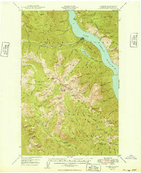
1949 Map of Lucerne
USGS Topo · Published 1949About this map
Lake Chelan dominates this 1949 topographic study, where the tiny settlements of Lucerne and Moore sit along the deep water’s edge. The remote mountain landscape is defined by the steep drainages of Railroad Creek and Domke Creek, with the latter feeding into Domke Lake beneath the lookout on Domke Mtn. Human activity is sparse but notable, with the Edil Mine located near Riddle Peaks and the Cottonwood Guard Sta providing a remote outpost in the southern high country.
Find a feature on this map
104 named features on this map. Tap any name to fly to it.
Don’t see what you’re looking for? This feature index may not catch every label — zoom into the map to look around manually.
Map Details
Editions of this 1949 Lucerne Map
2 editions found
Other maps of this area

1899 · Methow
USGS Topo · 1:125,000

1901 · Chelan
USGS Topo · 1:125,000

1901 · Methow
USGS Topo · 1:125,000

1901 · Chiwaukum
USGS Topo · 1:125,000

1902 · Stehekin
USGS Topo · 1:125,000

1904 · Stehekin
USGS Topo · 1:125,000

1904 · Chiwaukum
USGS Topo · 1:125,000

1944 · Holden
USGS Topo · 1:62,500

1944 · Lucerne
USGS Topo · 1:62,500

1949 · Lucerne
USGS Topo · 1:62,500