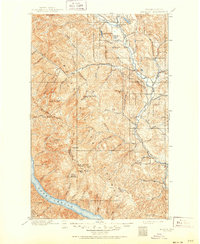
1899 Map of Methow
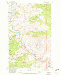
USGS Topo · Published 1963About this map
The Methow River corridor at the turn of the century shows a series of river-valley settlements establishing themselves along the eastern slopes of the North Cascades. During this survey period, Winthrop and Twisp served as early commercial hubs for the surrounding drainage basins of Wolf Creek and the Twisp River. The landscape is defined by the transition from the high, glacially carved peaks of the Sawtooth Ridge and the Chelan Mts down to the fertile flats where Carlton and Methow are situated. The presence of several high-elevation lookout stations, including those at Milton Mt, Buttermilk Butte, and Nelson Butte, highlights the early importance of fire surveillance in the Okanogan National Forest. Unique geomorphic features like Elbow Coulee and Pipestone Canyon illustrate the complex drainage patterns that early settlers and surveyors navigated before the development of modern highway systems.
Find a feature on this map
75 named features on this map. Tap any name to fly to it.
Don’t see what you’re looking for? This feature index may not catch every label — zoom into the map to look around manually.
Map Details
Editions of this 1899 Methow Map
This is the sole edition of this map. No revisions or reprints were ever made.
Historical Maps of Twisp Through Time
5 maps found