
1920 Map of Slate Pass
USGS Topo · Published 1920About this map
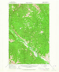
The Cascade Range crest divides this high-altitude wilderness survey, where the Chancellor Power Plant stands as a rare industrial marker amidst the peaks. Established in the years following the 1918 forest surveys, this map documents the intricate drainage basins of the Pasayten River and Lightning Creek as they flow from the international boundary toward the interior. The landscape is defined by its critical mountain passages, including Slate Pass, Harts Pass, and Washington Pass, which historically served as the primary routes for miners and early forest rangers.
Find a feature on this map
73 named features on this map. Tap any name to fly to it.
Don’t see what you’re looking for? This feature index may not catch every label — zoom into the map to look around manually.
Map Details
Editions of this 1920 Slate Pass Map
This is the sole edition of this map. No revisions or reprints were ever made.
Other maps of this area

1899 · Glacier Peak
USGS Topo · 1:125,000

1899 · Methow
USGS Topo · 1:125,000

1901 · Glacier Peak
USGS Topo · 1:125,000

1901 · Methow
USGS Topo · 1:125,000

1902 · Stehekin
USGS Topo · 1:125,000

1904 · Stehekin
USGS Topo · 1:125,000

1955 · Concrete
USGS Topo · 1:250,000

1958 · Concrete
USGS Topo · 1:250,000

1962 · Concrete
USGS Topo · 1:250,000
1962 · Mazama
USGS Topo · 1:62,500