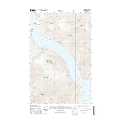
2014 Map of Lucerne
USGS Topo · Published 2014About this map
Lake Chelan dominates this landscape, serving as the primary corridor for the isolated settlements of Lucerne and Moore. The importance of water-based travel is evidenced by the Chelan-Lucerne Ferry route and the Lucerne Ferry Landing, which link these remote outposts to the rest of the county. Within the Wenatchee National Forest, the topography rises sharply from the shoreline to heights like Horton Butte and Bearcat Ridge. Domke Lake Resort sits tucked away near the shores of Domke Lake, surrounded by a network of recreation sites including the Domke Lake and National Recreation Trail. Along the western shore, Moore Point and its associated Moore Point Campground mark another node of activity. Numerous drainages such as Railroad Cr, Fish Cr, and Emerald Park Cr carve through the steep terrain, illustrating the complex hydrology that feeds the deep glacial lake.
Find a feature on this map
52 named features on this map. Tap any name to fly to it.
Don’t see what you’re looking for? This feature index may not catch every label — zoom into the map to look around manually.
Map Details
Editions of this 2014 Lucerne Map
This is the sole edition of this map. No revisions or reprints were ever made.
Other maps of this area

1899 · Methow
USGS Topo · 1:125,000

1901 · Methow
USGS Topo · 1:125,000

1902 · Stehekin
USGS Topo · 1:125,000

1904 · Stehekin
USGS Topo · 1:125,000

1944 · Lucerne
USGS Topo · 1:62,500

1949 · Lucerne
USGS Topo · 1:62,500

1955 · Concrete
USGS Topo · 1:250,000

1958 · Concrete
USGS Topo · 1:250,000

1962 · Concrete
USGS Topo · 1:250,000
1968 · Big Goat Mtn
USGS Topo · 1:24,000